Bagstr 288 Posted July 20, 2016 OK, Face It. July is the time of year When You plan your escape. The temps in the Dez and even the mountains are death defying to annoying. What is your plan, where are you going to escape? Randy is doing the Total Bale, i.e. Alaska. Share this post Link to post Share on other sites
Covered in Dust 163 Posted July 20, 2016 I remember that place. This was just about 50 miles before the incident. CiD Share this post Link to post Share on other sites
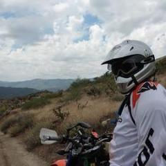
Bagstr 288 Posted July 20, 2016 Indeed, Just had my wheels trued, so good to go! Share this post Link to post Share on other sites
danrider 5 Posted July 20, 2016 Couple of big bear runs! Share this post Link to post Share on other sites
Sneeker 29 Posted July 20, 2016 This... https://drive.google.com/open?id=1r28ay6XhCJhVuZeiKZX6dOTohzE&usp=sharing https://www.youtube.com/watch?v=vE7r0tDvB-I Share this post Link to post Share on other sites
Bagstr 288 Posted July 20, 2016 Sneeker, Looks goood, Which Plate, small bike or the 600? How would you characterize the east vs west side. Is this one of your Explore the Unknown rides? At my limit for questions. Hope it was or will be a good time. Bags Edit; Nice Video, Thanks for the editing. Share this post Link to post Share on other sites
Sneeker 29 Posted July 20, 2016 The 650R is the machine. Need every CC when riding miles between 9k and11k. I don't think the pig will be too big for the trails. This is an unknown ride for me, although generally familiar with the area. In this case, instead of drawing the tracks from scratch, I grabbed a bunch of tracks off of GPSxchange, cut and welded them together to fit my need, and added a few custom twists. So, technically 85% of this ride has been pre-run on moto by a dude called CountDown on GPSxchange. East vs west? The east side will have more open country and higher elevation. The west side will be in the Sierra proper, more woodsy. The video is not mine. When researching the area I found that Youtoob and made it my goal to capture what's on there in my ride. I am 100% confident I have achieved that. Share this post Link to post Share on other sites
Bagstr 288 Posted July 21, 2016 The Bagstr is desperately working to tour the Gravelly Range and Centennial Valley in Montana. https://www.google.com/maps/place/Gravelly+Range+Rd,+Ennis,+MT+59729/@45.0511584,-112.1205725,10z/data=!4m5!3m4!1s0x5350f371511398e3:0xcabec858ede1823e!8m2!3d45.0511584!4d-111.8404158?hl=en Technically not that challenging but outrageous views. I have had travel setbacks because of an Airbag Inflator Recall on my Honda but have hope of making this happen in August. https://www.google.com/maps/dir//Unnamed+Road,+Alder,+MT+59710/@44.895161,-111.839275,3a,75y,90t/data=!3m8!1e2!3m6!1s419493!2e1!3e10!6s%2F%2Flh4.googleusercontent.com%2Fproxy%2F8o5K31y3rP-jRzfD2nbCK_-OLJMmYAoR3q5D7MewLV23K_V6fFmetS7Ic7pAtUKLKrMUF1pfjjc-qHIjnUjmmn-9JcI%3Dw203-h152!7i2304!8i1728!4m8!4m7!1m0!1m5!1m1!1s0x5350f3d5a872e953:0x9e88ab847cfe4dc!2m2!1d-111.8581489!2d44.9245722?hl=en Bags Share this post Link to post Share on other sites
Crawdaddy 96 Posted July 21, 2016 Summer season is mountain season......... Bass Lake/Yosemite last week Mammoth Lakes in 2 weeks Share this post Link to post Share on other sites
Dress4Less 162 Posted July 21, 2016 On 7/20/2016 at 8:53 AM, Sneeker said: https://www.youtube.com/watch?v=vE7r0tDvB-I Awesome viddy! Share this post Link to post Share on other sites
CVRick 42 Posted August 15, 2018 On 7/21/2016 at 9:10 AM, Crawdaddy said: Summer season is mountain season......... Bass Lake/Yosemite last week Mammoth Lakes in 2 weeks I will be staying near Bass lake next month. Where can I get trail maps for this area? Share this post Link to post Share on other sites
PbdBlue 46 Posted August 15, 2018 Just back from 8 days above Sonora and over in Mammoth. Had to dodge the smoke from all the fires but a great time none the less. Share this post Link to post Share on other sites
PbdBlue 46 Posted August 15, 2018 36 minutes ago, CVRick said: I will be staying near Bass lake next month. Where can I get trail maps for this area? A good start is to get a copy of California Trail Map. http://www.californiatrailmap.com/ Also get a copy of the Sierra National Forest map. PM me and I can send you some tracks. Share this post Link to post Share on other sites