Temecula Tim 0 Posted October 16, 2014 Did you guys stop at Capitol Reef Cedar Mesa campground on Thursday afternoon? No we were their on tuesday afternoon. Were you out riding around ? Scratch all that we were close on Thursday. I am checking the map. Ya we were on the Burr Switchbacks around 1 PM I pulled into the campground that afternoon as some riders were leaving. Pretty sure I saw CA plates. Was driving a Tundra with a 4-wheel pop up camper. I sure wish I had at least one of my bikes. That area is awesome. Share this post Link to post Share on other sites
Strega 0 Posted October 16, 2014 Always carry your radio tuned to 146.505 and call em out! Share this post Link to post Share on other sites
Bagstr 287 Posted October 16, 2014 The credit for 80% of the Tracks goes to KKug. He provided most of the tracks he and his Spies have collected over the years. Bagstr did the final editing and added a few locations which I was interested. Now I have a few edits of routes that did not work out or were errors. Fun story of getting lost in the wild spaces at sundown to be told. Doesn't get better than that! I will take credit for keeping my new Montana operational and increasingly functional over the length of the ride. B Share this post Link to post Share on other sites
Sneeker 29 Posted October 16, 2014 Fun story of getting lost in the wild spaces at sundown to be told. Doesn't get better than that! B It does, if you're super low on gas too...but still make it. Looks like it was a fantastic trip. Thanks for the write up and pictures! Share this post Link to post Share on other sites
Bagstr 287 Posted October 16, 2014 Day 3 dawned on the Group camped on BLM land with an eastern view of Capital Reef National Park near Fruita. Day 2 mileage proved to take much more time than a casual glance at the track mileage would suggest. Boulder Top turns out to be accurately named. No 45 mph power slides happening up at 10,600 ft. Just a long slow slog out to Chokecherry Point and down the cantaloupe rocked ATV trail to Hwy 12. I have been looking at that trail for two years wondering if is a ride-able route. I do not recommend riding it up-hill unless your name is Spaugh, Slut or Sic. Certainly not on anything bigger than a 450 moto. It was 4;30 before we contacted pavement and we still had 30-40 miles of either pavement or the much more interesting Pleasant Creek track into Capital Reef recommended by Ken. I lobbied for Pleasant Creek and won the day with only minor grumbles. Possibly the grumbles were from the stomachs of my buddies expecting lunch up at Fruita hours past. Poor Ken spent hours waiting for the riders to show up. Thanks buddy! We had to change our plan for camp as we were never going to make the 9000ft Cathedral Valley overlook camp 50 miles away. Back to day 3, destined to be a long day. We crossed the Fremont River and routed north on the Hartnet Rd. to the Lower and Upper Cathedral Valley Overlooks. Fun two tracks through highly variable but mostly fast going. We were stopping at 1 hour to turn back, as we had miles to travel. The views took awhile to develop, but with CIDs urging we persevered to the good overlooks. Glad we did. Turned back to see the Henry Mountain 50 - 70 miles to our south. Yes men, we are camping on the south side of all you see! Back across the river to the BLM camp and a session of maintaining a Rapidly deteriorating chain. Must of been 11-12:00 by the time we struck out south on Notom Rd. Turn east at the Sandy Ranch, traverse the washes to the rocky climb toward McMillan Spring on Mt. Ellen. We had to earn the tremendous views up-hill of Willow Spring camp. We were now headed to 10k and above through the forest on slippery loose rock via the School Buss trail. Terrific, but it hammered one of our riders and his bike which stopped starting with the e-button. Can you say bump start on mountain two track? Eventually made it to Nasty Flats and the easy route south through numerous herds of deer, 20 or 30 at a time. We must have seen over 100. The hunters definitely are not keeping up. The high 10,000 ft ridges around Ellen, Pennellen and Mt. Hillers were fun and fabulous views! The trip south to Star Springs camp took hours and light we did not have. By the time we arrived at lower elevations we were tired and in a hurry. But Wait! This is when the real fun started. I need to go clear a sink, back later. Share this post Link to post Share on other sites
Covered in Dust 163 Posted October 16, 2014 Some random shots. Day one leaving my house for the drive to Parowan, UT. Dave showing us the proper way to cross a stream. Eddie was a little rusty after not riding dirt for a few years, but got back up to speed after a couple of days. Gentleman Dave, thanks for putting up with us and for making this a great ride. CiD Share this post Link to post Share on other sites
Bagstr 287 Posted October 16, 2014 CID We know you are hiding at least one more picture of a guy in Blue and White on the deck with a "Why Me" expression. We are survivors, right buddy. Share this post Link to post Share on other sites
Bagstr 287 Posted October 16, 2014 About 6:00PM, south heading, eight hours into our riding day the trail is becoming more and more diminished. What could be wrong? From the comfort of my desk it appears we were on Cow Flat Trail, southwest of Mt. Hiller. Ghost Ridge is behind us over the left shoulder. Pennell Creek Bench on our right, Copper Creek Bench on our left, Mordor staight ahead. Eddie's radio is dead, Chris' gps 60csx has only maps. Most dangerous, Dave has a tracks marked out from the comfort of home. You may imagine a lively discussion over the two working radios. Track 1 is the route KKug lead us through two years ago which includes a "No Return" two track drop to a known washout with a sketch work around. Track 2 is a Benchmark "Other Trail" with the faintest of faint red lines. Cow Flat trail shows a dead end on Chris' 60. We explored Track 2 up a soft climb heading west with the hope of a southern turn around the corner. We will never know as we lost faith in the trail and turned back. Getting late we gave up the ghost and headed north, retracing our route to the main Star Springs graded road. Dusk turning to Dark, one good headlight. The Kug was responding to the radio as we closed, Mr. Reliable. Hugs all around, set-up tents in the dark while King Kug cooks dinner. Share this post Link to post Share on other sites
Bagstr 287 Posted October 16, 2014 The whole reason we initiated this ride was to find a rocky outcrop site that struck some as an Indian ceremonial site. Clay Point Rd. is wide, graded and soft between Star Springs and Notom / Bullfrog Rd. Ten minutes from our camp a green track from our trip two years ago runs north. With the confidence of morning, the three of us turn north in search of the tracks we lost faith in last night. A mile or two in there is a 200ft climb up a soft two track. At the top CID and I survey the situation. To the west a road looks as if it could connect with the western faint trail from the north. To the north ??? Chris turns back to Wakemedic as I promise to return in ten minutes after checking the north route. Thirty minutes later I had found Kugs old route south and the rock outcropping we where hoping to find. As I rode south to return, CID was riding north and we were able to confirm the connection. This was a fun few hours exploring and finding in the morning light. Share this post Link to post Share on other sites
Covered in Dust 163 Posted October 16, 2014 It was much more fun exploring in the light of day. Something about unknown trails or no trails and darkness fast approaching plus one balky bike and one dead radio made me want to get to camp where I knew there was hot food and cold beer waiting. I would have been very unhappy with myself if we hadn't found the spot we'd been talking about since our last trip in this area. Somehow this area has taken on mystic proportions with this group and someday we'd like to camp there overnight and see if dead indians haunt us all night. CiD Share this post Link to post Share on other sites
Covered in Dust 163 Posted October 16, 2014 Chokecherry was a fun trail, but I would not want to do it on my 950. Here is a nice spot to stop for a picture or two. When Dave took off I think he zigged when he should have zagged. Eddie being a good student decided to follow suit. I took a different line. CiD Share this post Link to post Share on other sites
kkug 146 Posted October 17, 2014 Yep thats the Spot ---we need to go back . Share this post Link to post Share on other sites
Bagstr 287 Posted October 17, 2014 Seriously Dude? Yes, One last Wrap on the Utah Loop: After we Locked Down the location of the Mystery Camp we were late per usual, with miles to go. We always make lofty goals for the days events and fine them hard to accomplish. On Clay Point Rd. we did a Rip the the Tip of the Saleratus drainage then northward to the Burr Trail switchbacks for lunch. We had hopes of traveling down the 50 Mile Bench to Hole in the Rock historical site, but never made it. I drug the crew through the Wolverine Loop which slowed us. We spent our last camp in the BLM Little Spencer Flat area. As with every day, we looked over the map and decided what was available and what was doable. CID wanted to see the Hells Backbone area and we headed that direction after retracing our route on the fabulous Hwy 12 to Boulder. A brief stop at Posey Lake and a race to Ruby's to wrap the ride. A great ride is one where you find it hard to grasp all the terrain traveled and camped. Check Boulder from Hwy 12 From Backbone Bridge Share this post Link to post Share on other sites
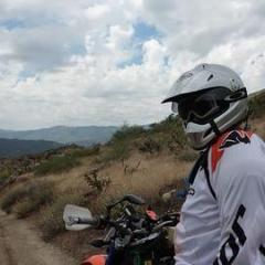
kkug 146 Posted October 18, 2014 Pitting Day 4 While the guys were out exploring I was checking out our campsite from a few years back. Still a great spot and now with two fire rings. While waiting at the Burr switchbacks I took a few pictures. Here they come ! Share this post Link to post Share on other sites
kkug 146 Posted October 18, 2014 After Lunch Dave led us ( Me included with the truck ) to Wolverine Loop. Then off to Boulder and our camp site off Hwy 12. It was my favorite of the whole trip. After the guys left the next morning I hung around and chilled . The next morn ! I checked out more possible campsites Then Back to get our trailer and load up. Me and Dave stayed in the cabin that nite . Almost the same as camping out. Share this post Link to post Share on other sites
kkug 146 Posted October 18, 2014 Back to San Diego. Stopped for breakfest, Took a spin to Zion National Park and then the interstate back home . It was a good trip and I enjoyed being the pit crew. I got a new ride planned and hope to pull it off next year --- Brapp !!!!!!!!!! Share this post Link to post Share on other sites