Bagstr 288 Posted February 22, 2011 Two or more of us are showing up @ Carrizo Wash South. The turn is the first right travelling north after Sweeny Pass. Check the map link. Most of the water should have stopped running in the washes and the sun will be out. Ride will be in Anza Borrego State Park which requires plated vehicles. http://maps.google.com/maps/ms?hl=en&ie=UTF8&msa=0&msid=215825752600436916279.00047ee21db83c6d9737c&ll=32.851615,-116.207542&spn=0.17132,0.267792&t=h&z=12&iwloc=00047ee22a8b8a7ca3f18 Hopefully we won't have quite the drama of the Desert Dash. Intermediate Challenge, lots of Deep Sand. Bring spare tubes, tools and snack / water. 75 to 100 miles. Share this post Link to post Share on other sites
Beezzz 6 Posted February 22, 2011 In. Is there a route south through foothills or only on S-2 to Dos Cabezas. Share this post Link to post Share on other sites
alyeska 50 Posted February 22, 2011 In, most of the water is gone, sunny and warm today. alyeska Share this post Link to post Share on other sites
Bagstr 288 Posted February 22, 2011 In. Is there a route south through foothills or only on S-2 to Dos Cabezas. Beezzz, http://maps.google.com/maps/ms?hl=en&ie=UTF8&msa=0&msid=215825752600436916279.00047ee21db83c6d9737c&ll=32.721985,-116.137505&spn=0.021446,0.033474&t=h&z=15&iwloc=000480bec8acc516c7811 Click the Google link and zoom in and out to see dirt two tracks. I usually travel south on Mortero Cyn, cross the tracks at the Water Tower followed by a loop through Dos Cabezas, back to the tracks, then north through the Volcanic Hills and Jojoba Wash. If you want to see this area, we can do it first, loop back by trucks for gas as needed, then head up Arroyo Seco del Diablo toward Alyeskas domain. Uphill toward Dave McCain Spring and the Pinyon Drop is scenic. Or out Fish Creek for a Really Big Loop. Share this post Link to post Share on other sites
Beezzz 6 Posted February 22, 2011 All sounds good. First day out with the injured wrists. Still troubled. Smaller day is preferred for me. Another day. Another question. Is it possible to trail to In-Ko-Pah from Dos Cabezas? Share this post Link to post Share on other sites
HowsAbout 2 Posted February 22, 2011 In. Is there a route south through foothills or only on S-2 to Dos Cabezas. Beezzz, http://maps.google.com/maps/ms?hl=en&ie=UTF8&msa=0&msid=215825752600436916279.00047ee21db83c6d9737c&ll=32.721985,-116.137505&spn=0.021446,0.033474&t=h&z=15&iwloc=000480bec8acc516c7811 Click the Google link and zoom in and out to see dirt two tracks. I usually travel south on Mortero Cyn, cross the tracks at the Water Tower followed by a loop through Dos Cabezas, back to the tracks, then north through the Volcanic Hills and Jojoba Wash. If you want to see this area, we can do it first, loop back by trucks for gas as needed, then head up Arroyo Seco del Diablo toward Alyeskas domain. Uphill toward Dave McCain Spring and the Pinyon Drop is scenic. Or out Fish Creek for a Really Big Loop. I would like to join you on this ride but I am out if you do Pinyon drop or any riding at that difficulty rate. I have ridden a just about all the washes in the park and have gone up and down Diablo Drop. I think Pinyon Drop might be too technical for me and my DRZ400 Are you doing Pinyon Drop? Share this post Link to post Share on other sites
alyeska 50 Posted February 23, 2011 I am going to be coming up fish creek then up diablo towards you, let me know if you are coming that way (where so. carrizo intersects carrizo creek) if you are I will just wait for you at the junction of s. carrizo and carrizo creek, if not I will just meet you at the designated spot at the designated time. If we dont have to climb heart attack hill (pinyon mtn trail) it wouldnt hurt my feelings, but I am along for the ride! alyeska. Share this post Link to post Share on other sites
ADV Bum 205 Posted February 23, 2011 I would like to join you on this ride but I am out if you do Pinyon drop or any riding at that difficulty rate. I have ridden a just about all the washes in the park and have gone up and down Diablo Drop. I think Pinyon Drop might be too technical for me and my DRZ400 Are you doing Pinyon Drop? Like a wise OLD OLD timer told me the first time. Dont worry, you will end up at the bottom one way or another. YOU CAN DO IT! If we dont have to climb heart attack hill (pinyon mtn trail) it wouldnt hurt my feelings, but I am along for the ride! alyeska. Heart attack hill is supposed to be a one way (down). Share this post Link to post Share on other sites
Bagstr 288 Posted February 23, 2011 We are Not climbing Heart Attack Hill. I just noted we might head that way. We will definitely turn around. Please meet at the trees in Carrizo South per the Google Map. We will head south first to Dos Cabezas then reverse to travel north. One hour south then North toward Fish Creek. I will check in about 8:00 one last time. If you are comfy riding the Deep Sand you will be fine. There will be a couple of slick places in the damp washes but no big climbs or drop other than Diablo which is not that tough these days. Moggles and sand. Climbing Heart Attack was in Another Tread. Share this post Link to post Share on other sites
alyeska 50 Posted February 23, 2011 Will meet at the designated spot at 0900, if I am late just head out and I will find you,I am leaving borrego at 7am but sometimes it takes a little longer to get through fish creek after a big rain. alyeska Share this post Link to post Share on other sites
HowsAbout 2 Posted February 23, 2011 See you in the morning 09:00 Share this post Link to post Share on other sites
Bagstr 288 Posted February 23, 2011 " Is it possible to trail to In-Ko-Pah from Dos Cabezas?" Man, that would be one tough trail. Check with Spaugh. Seems that he and Pasta had some crazy ideas on that. See you gents in the AM on the moist sand. There are easy bail points if the wrists start acting up. Share this post Link to post Share on other sites
karlaeda 0 Posted February 23, 2011 I have a question...how the heck do you guys get out that far? Trucking it out for a couple of hours, or do you just camp there? -George Share this post Link to post Share on other sites
Bagstr 288 Posted February 24, 2011 I have a question...how the heck do you guys get out that far? Trucking it out for a couple of hours, or do you just camp there? -George George, It is about your priorities: Mileage: Temecula to Mission Center Rd. San Diego = 600 miles to Commute five days a week. Ramona to Mission Center Rd, San Diego = 350 miles to Commute five days a week. La Mesa to Carrizo Creek South = 180 miles to commute one day a week, 360 twice. I take my job seriously and am willing to Sacrifice to make it a success! Share this post Link to post Share on other sites
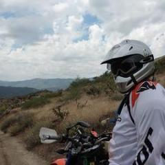
HowsAbout 2 Posted February 24, 2011 If you want to ride these days you have to go the extra mile. I went the extra mile, got in the above picture and had a fun day Share this post Link to post Share on other sites