isde97 30 Posted July 20, 2011 Still going on, so a full report will be coming later. The first two days were complicated by flats, 3 of 'em. It is a good thing I had a bunch of slack in the schedule, because I have been needing it. Today was just epic, though. It made up for a lot. Share this post Link to post Share on other sites
kkug 160 Posted July 20, 2011 Did you put new tubes in from the Bradshaw ride? That sucks ! Share this post Link to post Share on other sites
isde97 30 Posted July 22, 2011 I got some tubes that, as it turns out, were suitable 'for emergency use only.' Now that I have that sorted out, things have been going good. I am in Salinas now, I had a 170 mile ride yesterday with my daughter that went pretty good. I can't seem to remember my password for my Flickr account, so pics will have to wait until I get home. Share this post Link to post Share on other sites
isde97 30 Posted July 28, 2011 Made it home 1839 miles later. A lot of epic riding. No flats after the second day. I made it through a rather dicey situation, we will just say I learned a few things. Pics and report coming. Again I will claim to not be into big ride reports, but hopefully I can motivate someone to come along next year, provided I do this again. Share this post Link to post Share on other sites
isde97 30 Posted July 30, 2011 Day 1 (the goal/schedule is Big Bear) As I earlier stated, I got a later start than planned. I was doing some bike maintenance before I left, and when I went to start my bike the afternoon before, the battery was flat. Fortunately, I had another one ready to go, but swapping the battery on this bike isn’t the easiest task. I am going to have to shortcut some of the first day to keep on schedule. I decide there isn’t a whole lot of time savings to be had by bypassing Black Mountain Road, but this needs to be first on my list in the future. Lots of traffic, fast, slippery, and really not that much fun. Lesson learned. I bypass Cooper Cienega, and on the way to Anza, I get my first flat. Odd, I have been on pavement for quite a while. While I am replacing the tube, Peter and Nancy stop to help. I have the situation under control, but Peter has an air compressor. This saves me CO2, so we use this to get the rear aired up. Plus, they are definitely the type of folks who like to bank good karma. I now bypass Rouse Hill Road and take Bautista Road towards Hemet and then take Bee Canyon Truck Trail and Indian Creek Road up to HWY 243. I love this time of day, but it is kind of late and don’t hit 243 until 7pm. I decide I really should be on roads that get at least 1 vehicle/hour when there is less than 2 hours of daylight left. At 7:30 in Beaumont, I pull off the freeway, see the Holiday Inn, the Sports Bar and Grill across the street, and decide that is good for the day. Share this post Link to post Share on other sites
isde97 30 Posted July 30, 2011 Day 2 I actually have a hotel reservation in Santa Clarita this night, so that makes the days’ destination a little less flexible. I should still have plenty of time. I have planned a route from Oak Glen to “the big hairpin in 38” that I want to investigate. Much of my planning involves Google Maps and street view, where you can check out the ends of a lot of roads and see if there is a gate or if it even exists. Sometimes, you don’t see much and just have to go for it and see what happens. This route almost certainly does not, I passed a bunch of disapproving signs before I got to a locked gate. OK, time to move on. I take 38 until 7 Oaks Road and then hit Converse Road up to Big Bear. As soon as I get on the dirt, I feel the rear going down again. Odd, a second flat where I should not be getting flats. I think about the tubes I have on this ride, and they have a common brand and provenance. I inspect the newly flat tube, and it is cracked where it was folded in the box. The first tube doesn’t look so bad, but it looks like pinch flat holes, but right in the middle of the tread where you would not pinch a tube. I repair this one, but have no confidence in the tubes I have and decide I need new tubes. I also have enough CO2 for one more flat- not a great situation. Also, the bike seems to be running a lot hotter that I remember. My KTM in what seems to be it's natural state these days. I get to Big Bear, but can’t find a regular motorcycle shop. I find a Harley accessory place that has a heavy duty 19” Moose tube, so I buy that. I come up empty at a couple of bicycle/outdoors shops when looking for CO2. I have lunch, and decide to go straight to Wrightwood and the Angeles Crest Highway, so I can hopefully hit some non paved routes I have planned. While on a short Truck Trail I indulged in just before crossing I15 near CA 138, I feel the rear going down again. I nurse it to a gas station, put in the 19” tube I got in Big Bear, and run down to Chaparral for supplies. They don’t have the CO2 I want, but do have tubes. I buy 2 heavy duty tubes, and talk to the KTM tech about my bike’s temperature. He isn’t terribly concerned, so I take that as a vote of confidence and move on. It is now after 5, so I decide to just ride Angeles Crest to La Canada and take the freeway to Santa Clarita. AGAIN?!?!? Angeles Crest is just a phenomenal paved road. You wear down the sides of your tires way faster than the center. The last 30 miles are done on the freeway. Freeways suck. I get to my hotel about 7:30. There is a story about dinner this night. While doing my trip planning, I saw mention of a website called pubcrawler.com. When I went to check it out, the first of the new pubs listed was “The Bier Academy” in Santa Clarita. That works good enough for planning purposes, so I get a nearby hotel. After getting cleaned up, I walk over, order a beer, and ask for a menu. “Sorry, our kitchen closed early tonight.” I am pretty beat, so I consider just having beer for dinner. A couple of sips makes it clear that is a bad idea. The bartender says there is an Oggi’s nearby. Short on imagination, but long on the decent meal at 9pm. Incidently, when I am feeling behind schedule, I do not feel inclined to stop and take pictures. I am ready to change that. Share this post Link to post Share on other sites
isde97 30 Posted July 30, 2011 Day 3 I hit a Big 5 in the morning, and get 25 cartridges of CO2 and a backup tire pump. I am feeling better about my situation and preparedness. Last Thanksgiving, a trip up 395 to Carson City prompted me trying to tell my kids about the aqueduct, among other things (I am that kind of dad, they would really prefer to watch movies undisturbed). While doing some research about the project, I came across the story of the St. Francis Dam. I was certain I had been down the road and had no idea, so made a point to stop at the site. My GPS indicated this was the place, and I rode back and forth and didn’t see anything. I stop and hike to the top of the hill, and find the remnants of the wing dike and other debris toward the main dam. The largest civil engineering disaster in US history, and the second largest disaster in California history, and there is no interpretive kiosk, no marker of any kind at the site. I find this….. interesting. There is apparently a marker a couple of miles downstream at the pumping station, but that doesn’t seem quite the same. It is getting hot, and there is better hiking attire than full moto gear, in case you were wondering. Time for some good dirt roads, and the next section does not disappoint. Shortly up San Francisquito Canyon Road, I pick up Ruby Clearwater Fire Road and connect this through to Sandburg, dirt almost the entire way. Almost all this route is above 4000’, so the temperature is like 75 when the valleys are around 100. The views are stunning, and the riding is a blast. Lake Hughes in the background: Lunch at Pine Mountain Club: I then take Cerro Noreste Road out to the Carrizo Plain. Cerro Noreste is the complete roller coaster of a road. Bummer about the condition of the road: This turns into the fabled Elkhorn Road. Since the Carrizo Plain doesn't get much rain, the faultline is easily visible, especially from the air. Among the more famous features is Wallace Creek (no relation). 4000 years ago, the creek bed lined up. 30' of this displacement occurred in a single quake in 1857. This required another hike in the heat in moto gear. The idea wasn't any better. I pass by California Valley, and decide to visit downtown: I want to invade and liberate Calsahara, but can't find it. Sometimes, I think we would be money and headaches ahead if I ran US foreign policy. A blast down HWY 58 gets me to Paso Robles at a decent hour to meet up with my family for a day's layover. This has been a great day of riding. Share this post Link to post Share on other sites
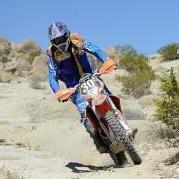
isde97 30 Posted July 30, 2011 Day 4 Both my kids wanted to ride with me the whole way, and were not pleased that they could not. Since this day is going to be 'shorter' and almost all paved, my daughter rides with me. It is still going to be a long day for her, we will see how she does. Vinyard Canyon Road approaching Parkfield. We stop at the Parkfield Bridge and I explain everything I know about plate tectonics. It doesn't take long. Morgan doesn't think they can build a straight bridge here. We stop at the Parkfield Cafe, and are disappointed to find it closed and only open Thursday through Sunday. It then occurs to me that it is Thursday, and a check of the door shows it is open. We have Chocolate Shakes, and Morgan explains to me how great Hot Pink is and what a fashion disaster Baby Pink is. Who knew. Looking back towards Parkfield from Parkfield-Coalinga road, the one bit of dirt we ride all day. Morgan is thrilled to find cattle in the middle of the road. We have lunch in King City, and then proceed to Carmel Valley Road. Morgan practicing her freestyle adventure riding on Carmel Valley Road: We ride into Carmel Valley, take the Laureles Grade over to CA 68, and to our hotel in Salinas. It was stinking hot as we were decending towards CA 198 from Parkfield, and pretty chilly when we got to Salinas. 5 miles from our hotel, we have to stop so Morgan can put on another jacket. Morgan did great. I go to the track the next three days, and meet up with Ken Saturday and Sunday. I think we had a beer on one of those days. Share this post Link to post Share on other sites
kkug 160 Posted July 30, 2011 Which beer was that I lost count ? Share this post Link to post Share on other sites
isde97 30 Posted July 31, 2011 Day 5, time to start heading home. Oh, Maannnn....... I leave Salinas, and take the Old Stage Road San Juan Grade Road over to Holister, and then down CA 25 to Coalinga Road. I have been down this road plenty of times when I lived up in NorCal, on my way to Clear Creek, but I have never been on the road past Clear Creek. This was a slight departure on my itinerary, I had planned to do this on the way up but cut it out to keep my ride with my daughter down to 170 miles. So I am going to do it now. EDIT- I had planned to take Old Stage Road, but it is now a non motorized trail. I had to route back and take San Juan Grade Road, which is not a bad alternative. Coalinga Road is the one going straight. 25 goes off to the right in the picture. This is a fun route. I stop and have lunch in Coalinga, which is a bit bigger than I was expecting (still pretty small). I have an excellent Calzone at 'Me and Ed's Pizzeria,' in case you need an endorsement of a place to eat in Coalinga. After lunch, I take CA 198 back towards Parkfield, and then take Bitterwater Road between 46 and 58. Bitterwater Road is another that is built right on top of the faultline. And then back on 58, to hit some dirt through the Pozo area and on to Arroyo Grande for the night. Since I am doing pretty good on my schedule, I decide to get off the graded dirt road and do an 'off route' alternate that my GPS indicates I can loop through and pick up my planned route a little later. At first, this provides an upgrade to the route and the already spectacular views. If I can ever get the video to upload, it is going to show me pausing briefly at a sign with words to the effect of "It is really gnarly coming up, and you can't turn around after this." My thoughts were something like: 'How bad can it be?' EDIT: got it uploaded. Keep your expectations low, half of this is me scratching my head trying to figure out how to get down what I was thinking was the really gnarly part. I still can't figure out how to embed video, the embed code from youtube isn't working. EDIT 2: fumbled my way to how to embed. Pretty Bad It doesn't look any better from up here. These are the Pozo Stairsteps. I had no idea that this was here. It is about 5pm on a Monday. I also run out of water about now. At this point, there is no going back up the 'road'. I can only go down. I contemplate abandoning my bike and walking into Pozo, which is going to be a hefty hike but I can do it. Trying to get my bike down this has 4 possible outcomes, 3 of them bad. 1. I drop my bike in a way that I can't pick it up. Very possible. 2. I drop my bike in a way that I can't get it back, like over the side. Also a decent chance of this. 3. I drop my bike in a way that incapacitates me. Also possible. This thing is a pig. 4. I make it down in a way that allows me to keep riding. I decide my chances of making it down are good enough to make me try. Notice in this pic how there are no stands down. It is not leaning against a rock. The back wheel is wedged between two rocks. The bike gets hot and gets cranky about starting. I let it cool down for about 10 minutes. I resolve to spend the rest of my days hunting down the person who sent me on this route and beat the living crap out of him. If you are going to be in a dodgy situation, you may as well have a nice view. Made it. Notice the left bag is missing, it got knocked off on a rock on the way down. I should have taken them off. I bent the latch, but I can still get it on and it still works. I also have the stock skidplate and do not have a sidestand relocator, because 'I don't do that type of riding.' I meet 'Denny', on BMW 1150 roadster(I think), a guy from Austin, Texas, who travels around and works on Emergency crews at races, usually NHRA. He worked the GP, and thought is was great. He is also a big fan of Central California climate, after coming from 110 temps in Texas. I am still pretty much buzzing from the stairsteps. The rest of the ride into Arroyo Grande feels like a coronation parade. I get to my hotel, get cleaned up and head down the street to F Mclintocks. I am feeling pretty damn happy to be there. Share this post Link to post Share on other sites
kkug 160 Posted July 31, 2011 Holy smokes thats nasty. I would have went back the way you come unless their was some goofy uphill. Good thing you made it out ok. Share this post Link to post Share on other sites
kkug 160 Posted July 31, 2011 Old stage rd has realy been beat up in recent years. A good place to set up supension ! Share this post Link to post Share on other sites
isde97 30 Posted July 31, 2011 By the time I get to where the pictures were taken, I was well past the point of no return. I thought the worst was past me. I am an idiot... If I ever get the vid posted, it will make me look worse. I am really too old to be pulling this kind of crap. Share this post Link to post Share on other sites
bikeslut 1 Posted July 31, 2011 Nonsense; you are an adventurer! Ok; you may be an idiot too but I appreciate the report Share this post Link to post Share on other sites
isde97 30 Posted August 7, 2011 Been busy trying to get unburied at home and work... Day 6 I finally got the video uploaded for day 5, in case you were interested and missed it. The destination for the day is Valencia, where I have a another meeting with the family. I am supposed to have a bunch of slack in the day for some Santa Barbara exploring. First up is a ride up Sierra Madre Road from CA 166. Miranda Pines Road from Sierra Madre Road. I was hoping the closure notice for Miranda Pines Road wasn't real. It was. This makes for a fairly long out-and-back route. It is worth it, though. As far as you can get on a motor vehicle,legally, on Sierra Madre. 40 miles down this road, there is another locked gate that you can get to from the Santa Barbara side. I will post up a G-Earth tour file that will make you cry over what could be, but isn't. I have to backtrack the entire way back to 166, and then pick up Tepesquet Road to Foxen Canyon Road and into the Santa Ynez Valley. I have lunch in Solvang. I am running later than I want, and will have to cut out some of my SB exploring I wanted to do. Onto West Camino Cielo. There can't be that many dirt roads over 3000' that also provide an ocean view: I don't think the pic shows it too good, but that is Anacapa Island poking up through the clouds on the horizon: Lake Cachuma: West Camino Cielo is on the West side of CA 154, and East Camino Cielo is on the East side (get it?) and paved through to where it intersects Gibraltar Road. This was a regular ride for me and my RD in my college days, since it was close by and twisty. I thought it offered a great view back then, and experience since then has made it seem even more extraordinary. Gibraltar Road intersects East Camino Cielo and continues onto Gibraltar Dam. It looks like the FS and other privileged folks are not letting the road go to seed. I had hoped I would be able to take this road down into Santa Barbara, but it is now a hiking/Mountain Biking route only. It looks like it would be worth returning for the mountain biking. This means I have to backtrack a bit to pick up the SB side of Gibraltar Road and down into SB. Once again, it is getting late, so I take CA 192 down to CA 150 through Ojai and onto CA 126 to get to Valencia. Another great day of riding, and I had to pass up a lot. Share this post Link to post Share on other sites
wonderwoman 0 Posted August 7, 2011 It's fun to follow your adventure. I look forward to more. Amazing that you made it down that staircase on your big bike. egads! Share this post Link to post Share on other sites
isde97 30 Posted August 17, 2011 I'm feeling pressure to finish up from all those sitting on the edge of their seats... Day 7 I am planning on hitting some FS roads between Santa Clarita and CA 14, with some overlap of what I had to pass up on day 2. All access is closed though, as I work my way to Angeles Forest Highway from Aliso Canyon Road. I get to Angeles Forest, and I should be OK for fuel if everything goes good. I don't have much confidence in that, though, so I head into Palmdale for gas. After 2 hours of riding, I am farther away from home than when I started. This turns out to be fortuitous, though, as the road I had planned on down from Mount Wilson to Mount Baldy is closed. I finally clue in to the fact that any road in or close to a recent fire is closed. This applies to both Angeles NF and Los Padres NF, where lots of roads in fire zones are closed. Hopefully, they reopen someday. So, Angeles Crest (not the same as Angeles Forest, pay attention) back to Wrightwood, and on to I 15 Not that I ever get tired of Angeles Crest: A bit of dirt near Wrightwood, this the Pinyon Ridge Truck Trail: I then take Swarthout Canyon Road to I 15. This involves grade crossings on Cajon Pass, one of the busiest Rail corridors in the Nation: I am a bit of a rail buff, but I have my limits. There are three lines here, and I could easily see being stuck here for an hour. As it happens, there is a gate for one line and another for the other two. Fifteen minutes later, I am on my way. I have to do the freeway drone to get to Corona, where I hope to pick up the Main Divide Truck Trail. I don't have a verified route, or alternate, here, so I have to continue onto Lake Elsinore and CA 74, where I can pick it up from there. Like a Parisian who has never been to the Eiffel Tower, I had never been on CA 74. The way it climbs out of Elsinore, and the views it provides, make it worthy of inclusion on this ride. No pictures at this time, I am running a bit late. So I pick up South Main Divide, and continue home. In spite of it's vicinity, I have never ridden this before. It makes you feel like you are a long way from anywhere: I then pick up Tenaja Truck Trail into De Luz. I had looked for this about a year ago, but had been intimidated by all the 'private road' signs people had posted on the side of a FS road. I didn't see those signs coming from the other direction. Now it is just a matter of going through Fallbrook and Bonsall into Carlsbad. After 1840 miles, the bike is not as clean as when I started: This TKC80 had not been run under power when I started. I am not sure if I should be bummed that a tire only lasts 2000 miles, or stoked that a knobby lasts 2000 miles: An excellent trip, and one I am already planning for next year (I like to say I have been to every USGP for motorcycles for the last 45 years). This makes a great excuse to make this kind of trip. Hope someone joins me for next year. Share this post Link to post Share on other sites
isde97 30 Posted August 17, 2011 The rumoured g-earth file. Hopefully, there is a 'tour' element, click on that to take the ride. About half of this is open, we can dream about what could be. The forum doesn't like .kmz files, so change the extension from .txt to .kmz and you should be good. The impossible ride.txt Share this post Link to post Share on other sites