SCHWINN 0 Posted August 14, 2009 Great pics guys, Thank you for taking time to take the pics, Myself and my whole office have been enjoying them. Share this post Link to post Share on other sites
RogerTOWM 0 Posted August 15, 2009 I'll take the log home in Tin Cup with the wrap around porch and dock.... Great report...hopefully get this one done at some point. (meaning the ride, for me) That's where we ate lunch. Not too bad a place. A handful of people stay there during the winter. They are snowed in, need snowmobiles to travel. Share this post Link to post Share on other sites
RogerTOWM 0 Posted August 15, 2009 Great pics guys, Thank you for taking time to take the pics, Myself and my whole office have been enjoying them. Hey Huffy, sorry you couldn't make the ride but I do have some pants you can borrow! Share this post Link to post Share on other sites
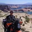
humptythumty 0 Posted August 16, 2009 Sunday August 2nd: This starts our 2nd week on the road. We leave Westfest heading South on the 24/291 and stop in Salida for breakfast. We’re headed to Pikes Peaks, a legendary place like Bonneville, Indy or Daytona. Seemed like a good destination plus where else can go to see what your bike runs like at 14,000 feet. At Westfest some locals had recommended a cool route. Just out of Canon City there is a dirt road through a place called Phantom Canyon. Bitching Canyon would be a better name. This road was awesome. Smooth dirt road starting in hot high desert (about 5,500 feet) and getting almost above the tree line (over 10,000 feet) in the ghost town of Victor at the end. The road continues into the gambling town of Cripple Creek. Scenic all the way with a tunnel and neat bridge thrown on to keep it interesting. Cripple Creek is about 6 miles North of Victor and we skip going there and head East continuing on dirt to Colorado Springs. The first Big city we’ve seen in a week. We jump on the freeway for a mile or 2 then hit the 24 West and in Cascade find a camp site. Monday, knowing we’ve been getting late starts most mornings we try to get on the road at a decent time. We get to the entrance of Pikes Peak and notice a sign stating short delays due to construction. No Biggie? This day was the only real bad day of the trip. Can’t really pass the big trucks going up the hill and the car drivers have no idea how to drive on a twisty mountain. It takes almost 2 hours to go 19 miles and at the top it’s a zoo. Massive amounts of people crammed in the gift shop and just way to touristy over all for our taste. The views were nice but not worth fighting the crowds or traffic for. We flew down the hill in a record 90 minutes for the 19 miles. There was one guy going about 2 MPH in every turn. I think Roger would have killed him if the hadn’t pulled off at the break check stop. We do a stretch of pavement and about 10 miles before Fairplay catch a dirt road over Weston Pass and down into Leadville. Going up the road is smooth and fast but heading down it starts to get a bit rough. Mud ruts, dips and rocks. 3 serious looking Harley guys ride up. 2 with no helmets but full almost outlaw biker attire. Real nice bikes 1 full dresser and 2 with raked out forks low and mean with lots of chrome and nice paint. What the f#%*$ are they doing o this road? The lead guy looks real concerned, he stops me a with a worried voice states “ We’re leaking oil” (3 guys on Harleys ride up and 1 says we’re leaking oil. Sounds like the start of a joke) I thought he was going to ask for oil but he wants to know how much further to the top. It’s a few miles and they plan to continue on. Before I ride on I tell him they have their work cut out for them. He tells me I do to. Not sure he knows the difference between 3” of travel with 5” of ground clearance and 10” of travel with 12” of travel. Out of Leadville we plan to catch dirt going over Hagerman Pass through the tiny town of Meredith then Basalt and Carbondale. We see how to get to the trail on the map but go in circles trying to find the right road. Map doesn’t seem to have brand name. It’s called Topographic Recreational Map of Colorado. One worthless piece of crap. Eventually we’re on the right road and it’s all good. Nice views and scenery. Snow and no trees at the top and a fun road town to Chapman camp ground where we spend the night. Next day we eat in Basalt and ride the Hwy South West to the town of Delta where the POS maps has us once again riding in circles. I talk with a cool old guy (could have been in his 90’s) and he gets us on the right track. We ride another good dirt road from Delta over Columbine Pass and into Nucla. We figure it’s about time to call it a day. We go West on the 90 and find no hotel. Realizing we’re not tom far from Moab we travel on and get the same cabin we had over a week ago. Wednesday: We go North out of Moab but before we get to the 70 we cut the corner on a dirt road that takes us through the mud hills eliminates maybe 20 miles of the Hwy. Not overly spectacular but better then the pavement. Out of Hanksville I get us going on the 95 instead of the 24. This adds about 50 miles for nothing to the day. Back on track we drop into Escalante looking at some awesome views. Earlier in our trip when we took Hells Back Bone we had by passed this area. Glad we got to see this time around. We stay in Escalante that night with the plan to ride down the Smokey Mountain Trail. The day we wake to strong thunder and rain. At the BLM center they say no way should we even try Smokey Mt. for at least a day to let it dry out. Major Bummer. We were shut out of Cottonwood Canyon our 1st day and now we are shut out of Smokey Mt. Plus it’s all pavement from here. Back in Page Roger goes for a nap and I take off to check some of the local sights. I hit Horseshoe Bend, some over look point the Dam and the power plant. After seeing the Power Plant with the 3 stacks from a far I was curious has to what it looked like up close. Much smaller then I thought. Our last day in Page and the 1st day of our trip with out a cloud in the sky. We decide to go to Alstrom point which was highly recommended by Don and then do Smokey Mountain to Escalante and return by Cottonwood canyon. This would be a lot for 1 day but would be a good finish to a great trip. Not sure if we made all the right turns but did get to Alstrom Point. Way cool place. Then we roll on. I have tracks for Smokey Mountain or so I think. They actually have us a bit East on Surprise Valley / Croton road. This is a fairly challenging road on the big bikes. Tight turns with lots of rocks and ruts. Although it was tricky I really enjoyed this road. I did wonder a time or 2 that I would come around a corner find an obstacle we couldn’t get over or around. This was a good test for Roger and he past without help. Not sure he had fun though. Coming down Cottonwood Canyon was fun and it was nice to have been able to complete the whole trail. We finished has the sun was going down, loaded the bikes into the truck at Don’s place and drove to Knab where we had reserved a room. The trip is over except the drive home and writing this report, both taking longer then I would like. Some things I learned from the trip: I’m a rider not a writer. I feel this report is long and a pretty bland, like I said I’m not a writer. You can really feel a shift in energy when your headed back as opposed to heading out. The DeLorme Atlas and Gazetteer is big and hard to use on a motorcycle but would have saved us a lot of time. Unless I have my entire route tracked out I will carry one on my next long trip. The more I ride, the more I want to ride. Does that make sense? 2 weeks sounds like a long time but it’s not. There were lots of towns and sights I would have liked to explore and spend more time checking out but it would have really cut into the riding time. This same trip done in 3 weeks would have been perfect. Life is simple when you don’t have much more then the cloths on your back, 2 weeks and a motorcycle. Simple is good. Take enough photos and you’ll get a few good ones. Things I left out. Lots of guys would ask what kind of bikes we were on, who made them and so on. I was surprised at how many people had not heard of KTM. Then a Grandma with her young grandson waves me over to her car while I’m at a gas station and asked “what kind of gas milage do you get out of that KTM” Cool G ma. I like talking with people and people I haven’t met are most interesting. On the trip I talked to a fair amount of folks and when I would mention the economy 100% of them were afraid of what was going on in Washington and did not agree with what was being done. Make of that what you want. Met a guy at Westfest who had planned to do a 2 week trip around Westfest. He had a BMW 800 and was having all kinds of trouble with it. When the shop couldn’t make the repairs in time for his trip he bought a new KLR just so he wouldn’t have to miss the ride. I didn’t ask but I’m guessing he’s not married. Love his spirit. Thanks again to Zenosan for helping with the truck, letting us park in front of your home and for the riding tips around Page. And also thanks again to Martoon for the KTM info. Our trip would have not been as enjoyable with out your help. Wayne Pictures: http://picasaweb.google.com/Adventuredude8...ktIwounlC_AqyA# Share this post Link to post Share on other sites
Crawdaddy 96 Posted August 16, 2009 The more I ride, the more I want to ride. Does that make sense? Totally...... Read every word.....checked out every photo - GREAT STUFF ........ Glad you two were able to carry the torch for the rest of us....... Share this post Link to post Share on other sites
RogerTOWM 0 Posted August 18, 2009 It’s funny how two people can see the same thing differently. We were riding down Weston Pass road. After hitting the highest point the road enters another county and is not maintained. We start hitting some rough section that has been eaten up by cars and trucks. There are rocks sticking out everywhere and deep dips. But the worst are all the ruts. Catch your tire on one of those and it is going to throw the big bike down quick. I’m doing alright. The past few days of riding has taught me a little on how to throw the big KTM around. I’m starting to think that I am really something when I have to stop for a SUV or MiniVan or some such making more ruts in front of me. It pulls over to the side and three motorcycles pass it. Three bikes? WTF? they are Harleys! The last bike is a sportster with a 20 something riding it. Ok the sportster weighs about the same as my bike. Not nearly the suspension travel but it is a 20 something kid riding it. Not a 52 year old bald headed fat guy like me. The 2nd bike is an Electraglide! The middle aged guy riding it took the bags off but it is an electraglide! That has what, maybe 4 inches of ground clearance max and weighs around 600 pounds striped? The first guy is closer to my age and is riding a Road King! WTF?!?! in one hand he is carrying a beer bottle! An open beer bottle! They don’t say anything to me as they ride by. They sure took the wind out of my sails. I‘ll tell you when you get to thinking that you have started to master something. Nothing will set you straighter then having a guy pass you on a Harley holding a beer bottle in one hand! Maps are no good at all if they don’t tell you anything! Humpty had been leading the trip the whole time. He had taken Crawdaddys route and joined it with some other routes to give us some great roads to take. I had been quite content to let him do all the work. I didn’t even bring a map! I had planed to but forgot them at the last moment. The last part of the trip he had a map that didn’t even have a scale on it. We couldn’t tell a thing about this map. I showed a road making a right and then a left. At the left we should go straight and intersect with a nice dirt road. Only on the ground the road turned all over the place. Left, right, left, right, left, heck I thought I was back in the infantry again! For two days we lost several hours and got lots of unneeded tension because of that map! I would like to TALK to that map maker sometime! But with Wayne’s skills at making new friends we were always able to find our way. The last day of riding may have been the best. Although we were no longer in the Rockies of Colorado and all that entails. The night before we had talked to Zenosan. He told me that he had explained a route to Wayne that I would really like. It had some cliffs or high spots but was so beautiful that we should not miss it. We rode out to a lookout above Lake Powell. We may got off track getting there and went through some dry mud that really threw my bike around. I dropped it once and had to have help picking it back up. Every time we lifted the bike the back wheel would slide out putting the bike down again! But the view was worth the trip! We then rode to what I thought was Don’s route up the cliffs. It was an old mine road full of rocks, ruts, steep switchbacks and washouts! It kept going up and up and I started cursing Don. As I threw the big bike around, trying to miss the rocks and ruts and washouts and just stay on the road without going off of the edge of the cliff. The switchbacks were the worse. They were steep, rutted, washed out and rocky. There was nowhere to stop the bike and catch your breath. To stop and try and restart would more then likely throw me of the edge of the cliff. The trick was to keep gassing it, run with the bike, throw it away from the edge and curse Don for directing us this way. What was that man thinking! We are on big bikes not little 125 smokers! In some spots there is almost no road at all, I’ve seen single track better then this. After a few miles we get onto a nice, graded high speed road. We only have to worry about washouts as we travel further through the mountains. A few miles of this and we reach a sign that says Escalante and Big Water. WTF we just left Big Water this morning! What is wrong with this sign? At the ranger station we find out that we were on Croton Road it was the wrong road. The lady was surprised we survived that road and she didn’t see that we were on big bikes. So sorry Zenosan, it was Wayne’s GPS I should have been cursing not you sir. Share this post Link to post Share on other sites
Crawdaddy 96 Posted August 18, 2009 The last day of riding may have been the best.......We rode out to a lookout above Lake Powell. We may got off track getting there......We then rode to what I thought was Don’s route up the cliffs. It was an old mine road full of rocks, ruts, steep switchbacks and washouts! It kept going up and up and I started cursing Don. As I threw the big bike around, trying to miss the rocks and ruts and washouts and just stay on the road without going off of the edge of the cliff. The switchbacks were the worse. They were steep, rutted, washed out and rocky. There was nowhere to stop the bike and catch your breath. To stop and try and restart would more then likely throw me of the edge of the cliff. The trick was to keep gassing it, run with the bike, throw it away from the edge and curse Don for directing us this way. When we rode a similar loop out to Alstrom Point with Don and Gawin last Spring, we rode in a clockwise direction out of Big Water........we took the Fish Hatchery Rd. out across and along Nipple Creek to Tippets Canyon Rd.......Tippets took us over to Smokey Hollow Rd. where we headed straight north before reaching Missing Canyon Rd. and heading south again..........Missing Canyon took us past the smelly/steaming coal and also allowed us to take in the view from Kelly's Grade.........then we dropped down Kelly's Grade and rode Recreation Road 264 out to Alstrom Point.....on the way back from Alstrom point we turned left onto Warm Creek Rd. at the intersection with Missing Canyon Rd.........Warm Creek led us back to Big Water......agreed.....very scenic loop......tried to find Croton Rd. on Mapsource (both City Nav and Topo)....no dice.....sounds like quite a detour You can view my cleaned up active tracks from that loop here: http://www.advrider.com/forums/showthread.php?t=475780 (Alstrom Point Loop is tracks 03 & 03A). It would be interesting to see where Croton Road falls into the mix..... Share this post Link to post Share on other sites
Zenosan 2 Posted August 18, 2009 Sorry you got lost Roger. I left the map of the ride in your truck. Chris is right. You were supposed to stay right from Smokey mountain onto Croton but only for a few miles. There is a sign about 7 miles down Croton directing you to turn right (south) to Alstrom Point. It says 5 miles to Alstrom Point. From what you described you did go the long way up Croton Road way (about 50miles) past the turn to Alstrom to connect up with Smokey mountain then Escalante. That is a very primitive road. I intended you to return by way of Croton bact to Smokey Mountain then go up Kelley Grade to Escalante. BLM Ranger vehicles patrol this road and is passable with a regular Jeep or truck. Don Share this post Link to post Share on other sites
RogerTOWM 0 Posted August 19, 2009 Sorry you got lost Roger. I left the map of the ride in your truck. Chris is right. You were supposed to stay right from Smokey mountain onto Croton but only for a few miles. There is a sign about 7 miles down Croton directing you to turn right (south) to Alstrom Point. It says 5 miles to Alstrom Point. From what you described you did go the long way up Croton Road way (about 50miles) past the turn to Alstrom to connect up with Smokey mountain then Escalante. That is a very primitive road. I intended you to return by way of Croton bact to Smokey Mountain then go up Kelley Grade to Escalante. BLM Ranger vehicles patrol this road and is passable with a regular Jeep or truck.Don Hey Don it wasn’t your fault. We had your map! But we were following a GPS track. Did you know that Wayne and Wrong Way all start with a “W”? Is this just a coincidence? You decide! At least some guy on a Harley Road King didn’t pass me holding an open beer in one hand! Share this post Link to post Share on other sites
Zenosan 2 Posted August 19, 2009 Sorry you got lost Roger. I left the map of the ride in your truck. Chris is right. You were supposed to stay right from Smokey mountain onto Croton but only for a few miles. There is a sign about 7 miles down Croton directing you to turn right (south) to Alstrom Point. It says 5 miles to Alstrom Point. From what you described you did go the long way up Croton Road way (about 50miles) past the turn to Alstrom to connect up with Smokey mountain then Escalante. That is a very primitive road. I intended you to return by way of Croton bact to Smokey Mountain then go up Kelley Grade to Escalante. BLM Ranger vehicles patrol this road and is passable with a regular Jeep or truck.Don Hey Don it wasn’t your fault. We had your map! But we were following a GPS track. Did you know that Wayne and Wrong Way all start with a “W”? Is this just a coincidence? You decide! At least some guy on a Harley Road King didn’t pass me holding an open beer in one hand! Ya wanna defend yourself on this one Wayne? Don Share this post Link to post Share on other sites
humptythumty 0 Posted August 19, 2009 Sorry you got lost Roger. I left the map of the ride in your truck. Chris is right. You were supposed to stay right from Smokey mountain onto Croton but only for a few miles. There is a sign about 7 miles down Croton directing you to turn right (south) to Alstrom Point. It says 5 miles to Alstrom Point. From what you described you did go the long way up Croton Road way (about 50miles) past the turn to Alstrom to connect up with Smokey mountain then Escalante. That is a very primitive road. I intended you to return by way of Croton bact to Smokey Mountain then go up Kelley Grade to Escalante. BLM Ranger vehicles patrol this road and is passable with a regular Jeep or truck.Don Hey Don it wasn’t your fault. We had your map! But we were following a GPS track. Did you know that Wayne and Wrong Way all start with a “W”? Is this just a coincidence? You decide! At least some guy on a Harley Road King didn’t pass me holding an open beer in one hand! Ya wanna defend yourself on this one Wayne? Don The trail we took looked flat on the the GPS screen. Put that W in front of right and see how it sounds. The most memorable path is usually not the easy path. Wayne Share this post Link to post Share on other sites
Crawdaddy 96 Posted August 19, 2009 The most memorable path is usually not the easy path. You tell'em Wayne!.......Better to lead and get lost than be clueless/following aimlessly...... Share this post Link to post Share on other sites
RogerTOWM 0 Posted August 19, 2009 The most memorable path is usually not the easy path. You tell'em Wayne!.......Better to lead and get lost than be clueless/following aimlessly...... Hey, I resemble that remark! And Wayne I just pointed something out! I’ll let others decide if there is any meaning to it. Again that was the best riding day of the trip. I'm ready to go for more. Share this post Link to post Share on other sites
Crawdaddy 96 Posted August 19, 2009 Again that was the best riding day of the trip. I'm ready to go for more. You'd enjoy the Mesquite/Page Loop......the stretch between Page and Fredonia is equally scenic...........and Bar 10........perhaps you'll both be able to join us for the Bar 10 ride next Spring Share this post Link to post Share on other sites
piratemonkey 0 Posted August 19, 2009 The most memorable path is usually not the easy path. ...he said after he hiked his way out of the forest without his bike two days later... Glad you guys are back sano y salvo. Are you two feeling a little more buff from lifting up your bikes a few times? Share this post Link to post Share on other sites
humptythumty 0 Posted August 22, 2009 The most memorable path is usually not the easy path. ...he said after he hiked his way out of the forest without his bike two days later... Glad you guys are back sano y salvo. Are you two feeling a little more buff from lifting up your bikes a few times? Zina, You might think after picking up the heavy beast a few times and wrestling it around for 2 weeks I would end up with Popeye arms. Didn’t happen. Still have me Olive Oyl arms. Ar ar ar. Wayne Share this post Link to post Share on other sites
RogerTOWM 0 Posted February 7, 2013 I'm thinking about going to WestFest again this year. Only this time I'll be starting from Texas. Anyone want to meet me there? Share this post Link to post Share on other sites