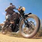
tvscum 43 Posted December 29, 2012 Whoever posted this track on Dualsportmaps, I blame you for too much fun until the sun went down! http://dualsportmaps.com/?link=100222 I had a lunch date at 12:30pm Friday with my high school friend in Oceanside at Johnny Mananas Mexican place (Pacifico on tap!). I spotted that Tenaja_DeLuz track starting from Oceanside and decided I would give it a try. Two tacos, two beers and one long story about a failed marriage later... it was 2pm. I went for the trail it anyway. Heading north through Fallbrook and eventually up De Luz Rd. there is left turnoff to De Luz TT where some property owners have posted "private road" signs. I don't believe it. The easy dirt road runs past a dozen driveways on the way up and looks like a Truck Trail to me. After that, Tenaja TT is cement and gravel the rest of the way. The views from that trail are awesome, and there is nothing technical about any of it. Very scenic. Turning green this time of year. It runs past Winomar OHV area (which was closed). I had never been riding on the west side of Murietta. Beautiful! I came down around sunset into Lake Elsinore. It was a fun solo ride, but the I-15 cold blast turned into a full-moon freeway ride. The moon was rising over Tierrasanta at 6:30pm. This would be a great noob ride in the future. Share this post Link to post Share on other sites
RobATK94 1 Posted December 29, 2012 great pics! i am thinking about riding this route next friday. got a new GPS for christmas and going to take it on a test run. looks like some good scenery. Share this post Link to post Share on other sites
FuzzyNugs 0 Posted December 29, 2012 Glad to see more people riding this route. If you have more time, I highly recommend continuing north of Highway 74 on North Main Divide to the northern Trabuca part of the Cleveland NF. Santiago Peak on a clear day offers great views of Orange County, LA, and the coastal islands. Share this post Link to post Share on other sites
tvscum 43 Posted December 30, 2012 Glad to see more people riding this route. If you have more time, I highly recommend continuing north of Highway 74 on North Main Divide to the northern Trabuca part of the Cleveland NF. Santiago Peak on a clear day offers great views of Orange County, LA, and the coastal islands. Man, I just checked that out on Google Maps. Looks like a TON of open space! Like... as much acreage as Camp Pendleton! Is North Main Divide all paved as well? Or does it turn into dirt up North? Share this post Link to post Share on other sites
FuzzyNugs 0 Posted December 30, 2012 North Main Divide is all dirt I forget where I turned off after Santiago Peak, but it ended up at this little mountain town surrounded by well..mountains and then dumped me out in northeastern Orange County. That day I cut through suburbia to I-5 home, but next time I'd like to either double back or take an alternate trail if one exists. I hate to waste knobs on the interstate. Share this post Link to post Share on other sites
X-country-Rider 0 Posted December 30, 2012 We need threads just dedicated to specific trails so people that ride them can post video of the trail and folks can post pics of the road. I was thinking of starting something like that on CAR if they would create a subforum for it to organize the threads. Share this post Link to post Share on other sites
tvscum 43 Posted January 1, 2013 I took some more photos yesterday of this same area. We drove there in a car and hiked up to Tenaja Falls. On the dualsportmaps link above, there is a dirt section of the route. This is the later, longer road that is all paved. Trail head to Tenaja Falls: Share this post Link to post Share on other sites
tvscum 43 Posted January 1, 2013 Tenaja Falls: The drive back up: View of Lake Elsinore from the Lookout Road House (restaurant and bar on the Ortega Highway): Share this post Link to post Share on other sites