Search the Community
Showing results for tags 'ridebdr'.
Found 4 results
-
CABDR with the DesertX, Section 8 - May 2023
padu posted a topic in 4 Days & Longer Trip Write-Ups and Photos
May 29, 2023 Bishop to Benton (reversed), 36 miles FIN! Section 8 is a short one. So short that we decided to take it in reverse on our way home day towards LA and San Diego. It's only 36 miles and it would be super fast, if not for an unexpected road closure due to the recent heavy rains. The Chidago Canyons were a pleasant and beautiful ride, and it was also nice to stop and check the ancient petroglyphs on the way to Bishop. After section 8 was finished, concluding our beautiful BDR trip, we stopped in Bishop for some great BBQ. Of course, to finish the trip with the full spirit of adventure, we had our first and only flat tire from all sections. -
CABDR with the DesertX, Section 7 - May 2023
padu posted a topic in 4 Days & Longer Trip Write-Ups and Photos
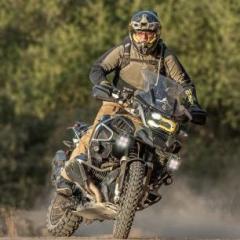
May 28, 2023 Section 7 is one of the most beautiful sections of the CABDR. Starting with an amazing view of the sunrise bathing the Sierra mountains from the Alabama Hills campground, we took Movie Road, where several movies were filmed, including the first Iron Man (Tony Stark demonstrating his latest missiles scene). Lots of water crossings and sand pockets. Then we arrive at Manzanar - where you will learn about a dark part of our history. For me, the highlight of the entire BDR was riding way into the Reward Mine, followed by the expert section going over the mountains on Hine Road. Absolutely breathtaking. We were initially planning on doing sections 7 and 8 today, but the day ran long and we went the highway to Benton, where we had reservations for a cabin. We had to ride the highway all the way to Benton Hotsprings Inn, so postponed finishing section 8 on our way home the next day, going North to South. -
CABDR with the DesertX, Section 6 - May 2023
padu posted a topic in 4 Days & Longer Trip Write-Ups and Photos
May 27, 2023 After finishing section 5, we stopped at Death Valley's Racetrack Playa (the famous and "mysterious" sliding rocks) for snacks. We knew section 6 wouldn't be the cakewalk that five was, but we were ready. The beginning of section 6 continues on Racetrack Valley Road for a short while, less than a mile, then it turns right for Lippincott Pass. The pass, which is really just a downhill, is part of the expert section for Section 6. The very first posted sign warns fellow travelers that there's no towing service for vehicles that venture down the pass, so proceed at your own risk. The road is rocky. In the beginning, it's small rocks, and the terrain, albeit sinuous, is easy to navigate. There's some exposure, so hug the mountain side if you don't like heights. As you start going down, the slope gets steeper, the rocks bigger and looser, forming steps of about 1 ft. in places that require some courage and momentum to overcome the steps. With some skills, though, any bike can pass. As you approach the bottom of the pass, the rocks get bigger, and the rain causes some big ruts. Line selection becomes a prime discipline. At times, we had to navigate very off-camber tracks to avoid the deep ruts. The challenge of this pass is not that it is super technical, but it is average technical for miles and miles. You will get exhausted if you're not in shape or your body position is not top-notch. Once you reach the bottom of the valley, there is not really anything challenging. You will find rocky roads and some sand, but nothing too gnarly. We ran out of water as we started climbing up and out of the valley. It was a scorching day, and Lippincott used much of our energy. It's a good thing we crossed a small stream and were carrying water filtration systems. The water didn't taste good, but it didn't kill us. We reached Cerro Gordo Rd., at the bottom of the mountain. The BDR website warned us of "deep sand" or something similar. We were a bit confused because we were not in a valley, and sand in that place would be misplaced. We were both right; it was not deep sand but deep, small, loose rocks. They were almost white, which made a very beautiful and peculiar white road, and yes, they were deep and it rides like deep sand. There are several bifurcations on the road, but they all follow the same direction and eventually merge ahead. Around the half point going uphill, the rocks become bigger, and traction improves. Very quickly, we were at the summit, where the Cerro Gordo mine is located. Unfortunately, there was an event that day - a marathon coming from the other side of the mountain with runners crossing the finish line at the mine; talk about craziness... We started our descent towards Owens Valley and Lone Pine. We were rewarded with the most amazing views of the snow-covered Sierras and the entire valley beneath us. The sky was deep blue and visibility was great. The descent is easy, but attention is required. The road is slippery, and there is a lot of traffic from regular cars, jeeps, side-by-sides, and even buses. We arrived in Lone Pine, a very quaint and charming town at the foot of Mount Whitney, the highest mountain in the continental USA at 14,505 feet (4,421 m). There, we met with another rider who would be joining the expedition the next day and followed the trip to Alabama Hills, a campground site on the road to Mount Whitney. The place is just stunning with its weird rock formations and the most amazing views of the sharp snow peaks towering up upon us. The only problem was that the sun was setting, and the place was packed with campers. We rode around for a good part of the hour and decided to camp in a place that wasn't really a designated camping site. We were exhausted, so nobody had trouble sleeping in our tents after a good steak dinner and some fireballs. We were hoping to finish the CABDR the next day... -
The best camera in the world is the one you have with you! As many here know, I snapped this pic of my son on August 4th while riding the Colorado BDR. I yelled thru the coms to STOP! Whipped out my phone and snapped this. Back into the pocket and off we went. Took about 20 seconds. Today Butler Maps and Backcountry Discovery Routes.org announced they would be putting this pic on the next printing of the COBDR maps. I feel kind of silly winning a photo contest with an iPhone. I’m just glad it wasn’t raining when I crested that summit!!