

AlphaOgre
-
Content Count
16 -
Joined
-
Last visited
-
Days Won
2
-
Those Baja Campers are pretty sweet, me bing so large though makes them smaller then they really are haha Mine is still available if you are still looking.
-
Sorry, I just saw this. The width of the ramp is 56". The width of the space between the bed folded up and the wall is 66" Its pretty lightweight, I towed with a VW Atlas (any SUV or small truck that can tow 5K LBS should work). I've towed it behind my 2500 too, and with that, the truck barely noticed it was there, which is also nice.
-
I've been camping with my bike pulled to some trips and it's really worked out well, it's a smaller trailer so it's very easy to use, pull, and maintain. It's been a perfect little ADV hub, but we also use it for other camping and family trips, so we are looking to get something a little bigger. Since it's such a great little bike hauler, I thought I'd post it here first and let other members get first dibs. Forest River Wolf Pup 17RR (also known as Cherokee/Wolf Pup 17RR toy hauler) Exterior Dimensions: Length (overall) -19 ft 9 in (237 in / 6.0 m) Width (body) - 8 ft 3 in (99 in / 2,514 mm) Height (exterior) - 9 ft 10 in (118 in / 2,997 mm) Weight & Capacity Unloaded Vehicle Weight (Dry Weight / UVW): 3,202 lbs (1,452 kg) Gross Vehicle Weight Rating (GVWR): ~5,361 lbs (deduced: 3,202 + 2,159) Cargo Carrying Capacity (CCC / Payload): 2,159 lbs (979 kg) Hitch (Tongue) Weight: 380 lbs (172 kg) Tank Capacities Fresh Water Tank: 50 gal (189 L) Gray (Sink/Shower) Tank: 31 gal (117 L) Black (Toilet) Tank: 41 gal (155 L) Propane Capacity: 9.4 gal (~40 lb) Structure & Chassis Axles: Single Brakes: Rear electric drum; no front brakes Leveling Jacks: Manual rear, electric front jack. Construction: Aluminum body; fiberglass sidewalls Tires/Wheels: 14″ wheels; spare mounted externally Interior & Layout Sleeping: Up to 5 (front double bed + convertible rear area) Slideouts: None (0) Climate Control: 13,500 BTU AC & 20,000 BTU furnace Water Heater: 6 gal propane/electric with bypass This is a compact toy hauler built for efficiency—it’s just under 20 ft long, 8 ft wide, and 9 ft 10 in tall. With a dry weight of about 3,200 lbs and payload capacity over 2,100 lbs, you’ve got decent room for gear, water, and supplies before hitting the GVWR. It rides on a single axle, has modest AC/heating, and no slide-outs. Has normal use and wear, with pitting on the front of the camper. Tear in the linoleum floor. Scratches and surface marks on cabinetry doors and shelves. stored under a cover, no leaks. All Keys/Locks work. Title in Hand. DM/ Message for more info. Would be open to trade if someone has a larger toybox-style camper and is looking to downsize. Only selling to roll money into a slightly larger option, less than 28' or so. $9,500 O.B.0
-

HWY 395 - Gateway to Epic CA ADV/Dual Sport adventure!
AlphaOgre posted a topic in 1 to 3 Day Ride Write-Ups, Stories and Photos
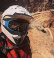
We do an annual trip to camp at Alabama Hills outside of Lone Pine, it's a trip set by my father-in-law and his other retired friends. I started taking my bike last year to go explore the roads and trails out towards Death Valley. This year, I thought maybe I'd go early and head up to Mammoth and explore some trails a day or two before. Then I realized Mamonth is only 1.5 hours south of Topaz where I had a buddy recently move to and got land at the base of the mountains which is now his backyard...at that point, I ended up taking the whole week off and leaving the Friday before to drive up. Since this was a multi-leg vacation (riding, meeting the wife for hiking, and camping with extended fam and friends) I took the bike in my little Forrest River 14RR toy-chest hauler. For a semi-impromptu half-assed trip, I have to say I had multiple days of riding that just blew my mind, it's exactly why you buy an ADV bike. An hour or so on the way to the trail, then hours up into the mountains and back down again... insane views and fun/comfortable overall riding all day! Started up top of CA with the first day being a day loop up and into Tahoe, the second day explored the east side of the valley making my way up into Nevada before turning back west and making my way back into CA... THE 89 HAS TO BE THE MOST UNDERRATED PAVED ROAD TO RIDE IN CA!!! It gets to you lots of trailheads, but would be worth riding alone! On this ride I went about 18/20 miles up into the eastside mountains of the 395, placing you up into Nevada, I was set to do it as a loop, but it was so beautiful and scenic, and I was alone for this trip, I ended up loosing daylight so I just came back down mostly the way I came. I was also soaked because I had to do a couple of deep water crossings and the nights were getting cold. This pic just perfectly encapsulated ADV riding for me, alone with miles of joy laid out in front of me and views that seem fake! For the Mammoth portion, My wife drove up and met me with a few days off, I was going to ride but the temps drops with a high of 50 and sustained 30mph winds, along with some major road closures i decided to just save the map for another time... all the more reason to go back! I planned it for one day on the west side and one day on the east side. Final Leg is down in Alabama Hills, if you watch bike launches, then you have seen these roads. Awesome place to ride and cruise around, you can go up the east side of the valley for more of a challenge and make your way to Death Valley. I had a route planned, but the guys I was staying with were hounding me to show them, so I ended up skipping the bike (knowing I would be waiting on them all day) and hopped in one of the Jeeps with the dogs. The original plan was to do a loop that goes up and around Cerro Gordo Ghost Town, but I spotted a trail that went into the mountains on one of my other rides around the valley so we ended up exploring that...it ended up connecting to the back side of Cerro Gordo, so now when we go back up, we can an epic loop from Independence over to Cerro Gordo all dirt and in the mountains. The trail out of Independence was stunning, every time we hit a new elevation or turned a corner we felt like we were in another state or continent! Its got long rocky sections, so I was kind of glad I was riding shotgun that day. Perfect ending to a day... coming out of the mountains with all vehicles and persons intact! Anyway, that's my report and sale pitch to just head up the 395 and see how epic this state can be, I daydream about going cross country or heading up it Alaska, but really we have some pure epic rides within 9/10 hours of highway with is a nice view for most the way anyway! Get out, ride, and explore! -
SD->Big Bear-> Joshua Tree Loop
AlphaOgre replied to AlphaOgre's topic in 1 to 3 Day Ride Write-Ups, Stories and Photos
Here are the GPX files, there are two since I broke it up into two days, and I wanted only the one I needed for each day for my Garmin 78 that I was using as a backup, it doesn't display the greatest, but it gets the job done and doesn't have issues. One is Vista to Big Bear, the other is Big Bear down through Joshua Tree and out the southern end of the park to come back through Borrego. I've heard there are mines and some cool stuff to check out on Burns Canyon, so I'm going to look into that and add them to the map when I go back in the fall. Spend more time exploring on the way up. @Oracle Of course my go-pro died so can't go back and see what part it was at exactly, so thinking back on where I came across the bear I wanna say it was on the 1N09 (City Creek trail) because it was on the nicer/smoother gravel section that was a break compared to the earlier part of the trail which was so rocky and rutted, it was definitely before I turned up Clarks Grade and started to go up more and it got rocky again. onx-markups-06282023 (1).gpx onx-markups-06282023.gpx -
SD->Big Bear-> Joshua Tree Loop
AlphaOgre posted a topic in 1 to 3 Day Ride Write-Ups, Stories and Photos
I took the BMW on the SD to Big Bear to Joshua Tree and back loop this weekend. I didn't realize we had such epic trails in our backyard! I used a trail to get from Hemet to San Bernadino then went up the west side connecting a few trails (Adler Creek Rd, City Creek Trail, Clarks Summit, to Mill Cr.) The west side was pretty rutted and rocky, so it took me longer than expected, but I found first gear was great for crawling down sections and keeping a slow steady pace through technical sections. I had some creek crossings which was a blast, and almost had an incident with a mid-sized bear running across the trail right in front of me! Definitely locked up the rear on that one! I've been wanting to get up to Big Bear since I've gotten the bike to explore some of the trails and now I'm just made I haven't done this sooner! I stayed the night in town and took Burns Canyon down the east side which popped me out right through Pioneer town. From there I went into Joshua Tree National Park, which is an awesome ride with some dirt roads and trails you can explore as well. The only bummer was the Southern dirt road/entrance was shut down due to a fire, so I had to backtrack through the park and then just take the 60 to the 10 and then just took the back way home through Palm Springs rather than go along the Salton sea and come back through Borrego. All told it was about a 430-mile loop with plenty of first and scenic views. I might do another version of it in the fall, temps were getting high in the lower parts of the trails, especially on the east side. 95-105, up the mountain it felt great! When I came down the east side I used Burns Canyon (2N02) which popped out basically in Pioneer town (red Waypoint Below), that road was not bad, with some sand at the bottom, maybe a mile's worth, and some rutted sections but easily avoidable along the edges of the trails. For the most part, I would call that road fun and easy for 90% of it, even the rutted or rocky sections are only for 20-30 yards, so easy to make it through or around. The southwestern part (1N16 Adler cr, 1N09 City Cr, 1N54 Clarcks Grade, 2N10 Mill Creek, 2N17 Camp Osito) was extremely rutted and rocky and I spent most of my time in 1st or 2nd gear ascending in rocky sections and descending in rutted and rocky sections. It was definitely a lot more work and I would say would be considered moderate with hard sections. You really need to be able to work your lines through sections of huge ruts and rocky sections. By the time I was getting to the top of the mountain, it finally got enjoyable again, enough to be able to look around and enjoy the scenery more. This was the first time I've used On X Offroad to plan the map and use the service while riding and I love it, I build the route in there and downloaded the GPX file and up it, on my Garmin as a backup, and the On X map was much more intuitive and easier to build routes in and read while riding. I didn't have a phone set up for the bike yet so I had the phone on my tank bag, but I will be looking to get a quad lock or something for my phone now so I can run On X. Things like looking up other trails or options while on rout was waaaaaay easier and faster. If I were to go back tomorrow and was with newer riders or riders that get tiered faster, I would go up and down through burns canyon, then explore along the top and trails that go down a little, around, and back up. If you are looking for a legit ADV challenging with different types of terrain and challenging sections you have to push through, the southwestern route is for you. -
Otay Truck Trail / Pink Gate Ride - Noob Friendly
AlphaOgre commented on tntmo's calendar event in Community Calendar
I'm looking to make it if I don't have to be on call for work, Sunday is more likely to be open for me... -
We need another ride!
AlphaOgre replied to moto_rph's topic in Informal Local Rides & Who's Going Riding!
Ive been itching to make it out to Oco since I have not been yet this season, Ill look into that for sure! -
We need another ride!
AlphaOgre replied to moto_rph's topic in Informal Local Rides & Who's Going Riding!
I'm out of town for the Rally and missed the last overnight ride, but I'm definitely down for the Romona to Big Bear. I would think it needs to happen soon though or wait till spring. That route seems to hit roads a few times so if people are getting tired or falling behind, there could be a turnback and head home via the roads. With the desert season coming up, there can be some big loop rides leaving Ocotillo to the Salton Sea and through split mountain through to San Felipe Wash too. It could be good to set up training/practice rides of sand or tighter trail loops too. 'm planning to take the BMW out a few times this season over the XR for exactly that purpose. -
Updated: Two-Fer Tuesday "Romantic" Black Mountain Night ride August 9th
AlphaOgre replied to Bub_Hannah's topic in Informal Local Rides & Who's Going Riding!
If the meeting time is at 5:30, when would kick stands be up to head up the hill? Trying to see if I can make the timing work since I would be leaving the office in Carlsbad. -
San Diego to San Bernardino - off road suggestions?
AlphaOgre replied to padu's topic in Informal Local Rides & Who's Going Riding!
This is a great little ride! I cant wait to try it, how long did it take? Curious about the timing, could you make it up and back within a day? -
Hi @tubebender Nice to e-see you again. Thanks for the welcome all!
-
New to Forum. North County SD
AlphaOgre replied to failedmusician's topic in New Member Introductions
I'm out of North County and new as well... There are some good trails not far from NC as well! Welcome! -
AlphaOgre changed their profile photo
-
Hi all, 👋 👋 👋 I grew up locally in the North County area, Carlsbad, and am currently in Vista. I currently have an F800GS with Touratech Front / Rear progressive spring upgrade. The second bike is an XR650L which has been updated with the Baja tank, Taller ProTaper Bars, suspension upgrades front and back from Race Tech, and all the usual upgrades to make that pig go just a bit quicker! I have to bring the bikes up to ogre standards being 6'7" and 265 lbs. I've been riding for the past 16/17 years or so, and have ridden everything from bobbers and cafe bikes I've built to Harleys and sport/street bikes. I started with dirt bikes out in the desert, so I've always loved the dirt, which is why I've settled in on the bikes I Have now. I love exploring and hitting all the trails San Diego has to offer, haven't ridden any of the ones down in east county yet, but soon! During the desert season, I love to go out and camp while exploring all of Borrego. Some pics of my rides are below. If you'd like to follow along and are on IG you can always follow @alphaogre. I ride weekends mostly since I'm far from retirement and work 9-5. Other than that, I cant wait to meet some other riders out on the trails and explore!
