

.jpg.84b6c67d2ec2e621b0662eef12b12ac3.jpg)
Oracle
-
Content Count
3050 -
Joined
-
Last visited
-
Days Won
4
Posts posted by Oracle
-
-
Android has a standard app called "my tracks". It might already be on your phne. Or like Jim said, any host of free apps like Gaia, Rever, Relive, onx....etc....
-
 1
1
-
-
10 hours ago, Bub_Hannah said:got it. Makes sense. Thanks for sharing that. I'm learning.
Jim is talking about the gate at the beginning of Lusardi Truck Trail (the formal name for the trail we are talking about) at Pamo Road. This gate is often closed, but seldom LOCKED. If it is not locked, then you are free to enter. If the gate is closed, make sure you close it. If it's open, leave it open. The other gate that is half way to the 76 is ALWAYS locked. Like I said earlier, it's easy to get around, and not a big concern to do so, but you'll run into the chain link fence maybe 100 yards up the road. So feel free to explore it a bit but you'll just end up turning around and heading back down. This area is my back yard. Let me know if you have any more questions.
-
4 hours ago, Bub_Hannah said:Thanks for the info folks.
Actually, Google maps (sat images) have been very helpful in determining where gates etc are....because you can actually see them. Is there a better option?
I'm certainly not afraid to explore and have been doing a fair amount. I typically will look up where I'm going on maps first to get my bearings. . In this case the map/directions were just not that helpful.
To answer your question more specifically, there is a forest service gate (easy to get around) and then a private party chain link fence that completely blocks the road at about the half way point between Pamo road and the 76, so that is the turn around point from the Pamo side.
-
-
Got it, thanks Mike. Looks like there is more in the area. I'd like to check out Valley of the Moons too.
PMB, next week is no good for me. But soon.
BTW, total elapse time to loan tracks into my phone...47 seconds. Hit download, open Gaia, click upload, click track, synch to phone....so easy...basecamp is so yesterday...
-
2
-
-
Thanks all. I've never explored this area....need to get out there.
-
1
-
 1
1
-
-
Where's this so called gnarly uphill mentioned above. Pin drop would be sweet.
-
How dare you not mention the 1090r in the group....you're fired!
-
On 10/26/2020 at 6:52 AM, PbdBlue said:When I look at the specs and the manual there's no mention of track storage\management. The Montana 700 series for example lists:
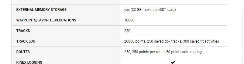
In the Zumo XT Specs there's no listing for track capacity so I'm assuming it's like every other Zumo in that regard. The Zumo series is not traditionally off-road oriented.
About 2/3rds the way down on the left side of the page, there's a bullet point on managing tracks and routes. Maybe I'm wrong, you are definitely way ahead of me in GPS technical knowledge.
-
On 10/20/2020 at 11:01 AM, PbdBlue said:The Zumo series has a fatal flaw if you are riding with tracks in that it will not store\display saved tracks. Tracks are the method most offroad users use to navigate. IMO the new Garmin Montana 700 or the Montana 610 would be better for backcountry trail use. I have no issues seeing my 610 in the sunlight.
Randy, the XT is brand new. And I believe it uses both tracks and routes. It is not like the previous Zumo units.
Robert, there are a couple guys on Flying Monkeys that just got these units within the last couple weeks. So far the input has been positive. I'm seriously consider one myself. Extra bright screen
-
Yes. Here is the starting point 32.58587, -117.00187.
I believe this is a public road but not 100% sure. I've ridden it a few times with no problems. There are a lot of trails off of this road that you can take over to Alta.
-
----, that sucks. Glad your injuries seem minor in the grand scheme of what we do. You going stick with the tubeless? Seems like a huge pain in the ass when there is a failure if you ask me.
-
Bummer. Sorry for the loss of your friend, Downs. RIP brother rider.
-
Nice, Jim. You're going love the Duraforce...enjoy getting to know it's simplicity.
-
21 hours ago, amgems said:The USB port has circuitry inside that pulls a small amount of power all the time. Switch is a plus. Right now I'm unplugging mine (when I remember) between uses.
The link is an interesting story but probably not what you intended to send. Maybe sumthin' like this? https://www.amazon.com/YonHan-Voltmeter-Motorcycle-Disconnect-Waterproof/dp/B072JM3NWG
Thanks LB ! Really appreciate the help.
Yes, that's the port I meant to link....LOL. Guess you got a lesson on the truth about Covid too... 🙂
Luna, I will say that makes sense and seems applicable to the type of issue I was having. I really liked the ease of use with the magnetic plug. I probably attempt it once more and keep a hard wire as my back up.
-
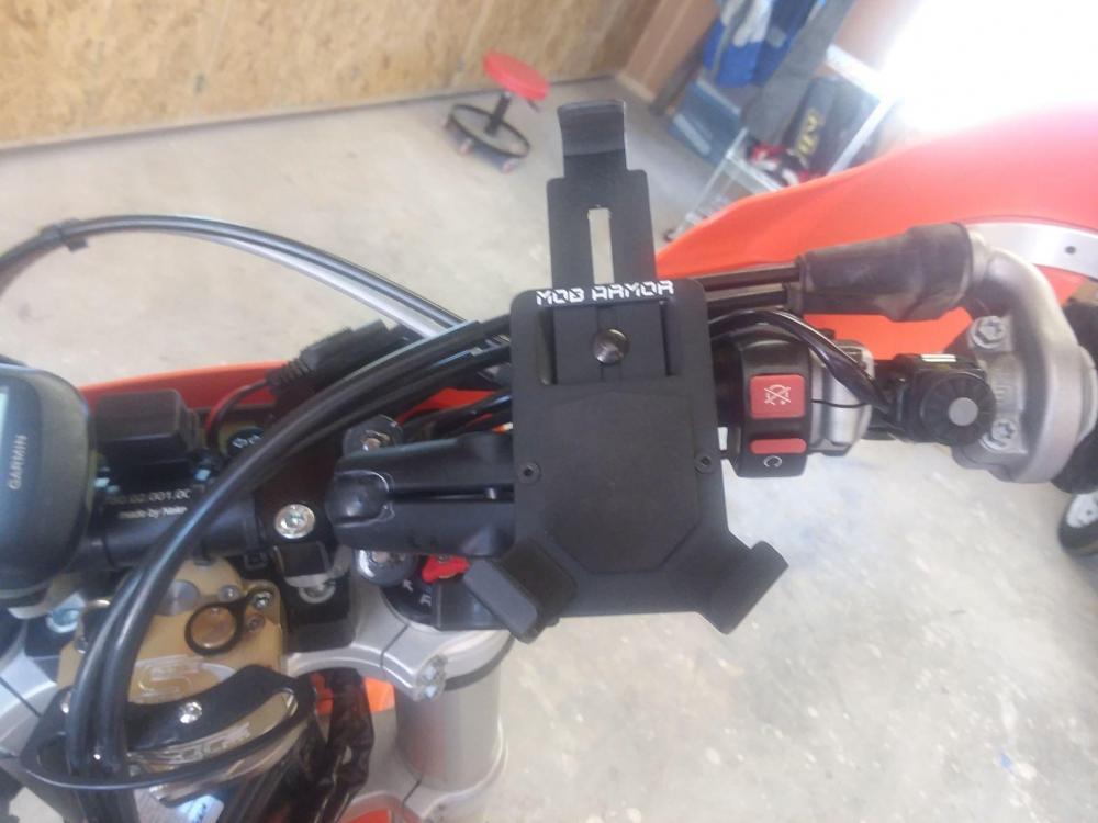
Jim, one more comment. I took the soft pad off the face of the mount and replaced it with velcro. Then put the opposite velcro on the back of my phone. This provide a backup to securing the phone to the mount.
-
On 7/4/2020 at 11:42 AM, amgems said:That's nice. Very much like the Mob Armor, but a much better price. I went with the Mob Armor. Found a used one on Amazon. Must have been a returned item. Got it for $37. Just like new.
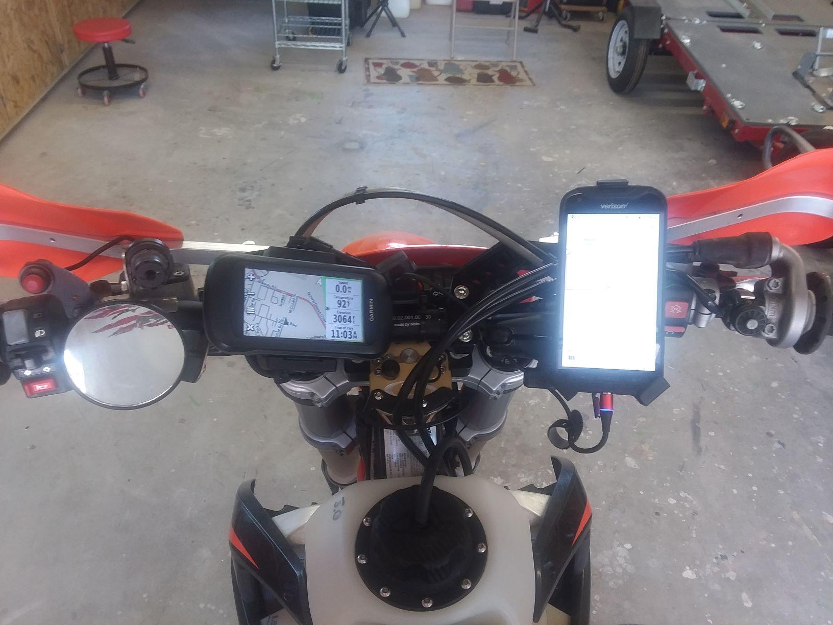
Here is my setup so far. Got the USB port and the magnetic plug that Luna uses. I've got the Mob Armor on a Ram mount. Probably still needs some tweaking. I've only tested it on the local neighborhood motocross track down the street. So far it's OK
The Dura Force Pro I got has a wonky charge port. I've got a new (used) one on the way. We'll see how that whole USB/power thing works out. I may just run on the phone battery.
LB, are you plugged in or running on the phone battery?

I'm running a double USB port charger with on/off switch and volt meter. https://www.kusi.com/dr-scott-atlas-disputes-covid-19-fear-mongering-tactics-from-our-health-officials/
I've been through several different USB charging ports. Two things I've learned. 1. You want at least 2 amps per port. The one I'm running now is 2.4 amps per port (4.8 amps total). 2. You want an on/off switch on the USB charging port. For some reason, the ones without the on/off switch have been linked to draining my battery over a few days of the bike sitting. Since I've upgraded to the on/off switch, I've not had that problem.
Having the volt meter is nice peace of mind too.
I know Luna endorses the magnetic charging cable. But I did not have success with it. I had problems with the magnet breaking contact with the mini usb charge port insert. I went back to a regular plug in USB to mini USB cord (make sure you use a quick charge one). The set up I have now has been successful at keeping my phone at 100% for the entire ride. That's with Gaia running on full brightness and Relive running in the background mapping my ride.
Running a GPS program on your phone merely using battery power will not suffice.
-
On 7/4/2020 at 12:12 PM, amgems said:Thanks for the feedback LB! From what I can tell, mostly from gigantic ADV Rider threads, is that, Gaia was originally made for IOS. They just created the Android version a few years ago. It did not work great at first. But from your experience and some other input from ADV Rider guys, it looks like they have fixed the problems. But it still is a heavy user of phone resources I guess. Not sure what that means. Maybe a battery hog.
I don't think you can download without service. I will do what you did, download what I think I need at home. And then use the sat maps offline.
I looked into the Garmin BirdsEye. It is a subscription for $30/yr (or $20/yr thru Amazon). Same deal, you download satellite images at home and use off line on the trail. People don't like it so much because the resolution is quite poor. I saw a video where a guy compared a BirdsEye sat map to Google map and Google was better. The 66i sounds interesting. Would be cool to be able to download as needed on the trail.
Have you tried downloading smaller sections yet in Gaia? Resolution OK?
With Locus Pro is you are limited to 10,000 tiles per day. Not sure how much area that covers. But you are getting real Google sat images with good resolution. Luna gets a big chunk of baja using it.
I have not tried smaller section yet but definitely well for the next off grid ride. For the Arizona Peace Trail, I downloaded 4 separate satellite sections. Basically I broke the ride area up into quarters and downloaded the sat image for each quarter to my sd card. Then as I was riding I would have a good idea off the top of the head which quarter of the map I was currently in. Then I would just pull up the image for that section. The concept is great. However, the max res for each section was less than desirable for the area size I downloaded. I believe if I would have broken the ride area into 1/8th, the data would have been much more useable.
The Garmin 66i just dropped $100 in price to $499. I'm thinking about adding one to my bars to replace my Garmin 78 (backup for my phone) and my Spot 3. It is a very nice unit. Has a useable size GPS screen, off grid two way text communication, 911 of course, on demand satellite download capabilities (no service needed).
-
Post a link for the unit you found please.
-
Just a quick update. I couldn't take the Ram X mount anymore. I hate how it swivels when the phone is in it and I hate how at least one of the arms is always touching one of the side buttons on the phone. So I've been running this $22 mount now for a few weeks. Several hard pounding rides on it and it's been flawless. Already has the 1" ball attached to it, heavy duty, and very securely holds the phone. I recommend it.
https://www.amazon.com/gp/product/B01N0UK9LQ/ref=ppx_yo_dt_b_asin_title_o07_s00?ie=UTF8&psc=1
-
7 hours ago, amgems said:Thanks to all for your help.
I have read that Gaia can be unstable on Android. Maybe old news.
Also read that downloading satellite maps into Locus Pro from Google Maps is difficult because the add on app (Locus Map Tweak) doesn't work well or is not easy to use.
Have you heard this or have any additional info?
I have been running Gaia all year. Lots of hard miles since I started using it on Android and not one problem When I did the Arizona Peace Trial, I downloaded the satellite images of the ride area before I left. I learned during that experience that I will need to download much smaller sections at a time in order to get the resolution I want. I'm not sure you can actually download satellite imagines or maps out in the field with no service?? Garmin offers this service on their newer 66i unit I know that.
-
I was driving home from Big Bear yesterday, heading down highway 38, and you passed me going the other way. Have a safe trip.
-
1
-
-
I'll be ripping up Big Bear tomorrow. But I'll jump on a Two For Tuesday soon.
-
3 hours ago, Ken S said:Black Mtn and a bunch of other dirt road stuff after leaving you guys.
210 miles for me today. 80 dirt.
No picsWere you with two other guys? One on a 790 and one on a DR???

12/26 Anza Borego Loop
in Informal Local Rides & Who's Going Riding!
Posted
Following. Can't commit yet.