


tvscum
-
Content Count
1035 -
Joined
-
Last visited
Posts posted by tvscum
-
-
-
Thanks for that info. I agree, I think what I need are TRACKS. I never need to be rerouted. If I get off the blue line I just ride back to it. I never need the line to change.
I suppose I am confused about whether you can upload TRACKS to the Explorer+, or only routes. The difference seems pretty clear from the Garmin site below.
I would like to use this as an all-in-one because then it is hardwired to the battery for GPS, it is attached to my handlebars in clear satellite view to send 10-minute tracking to my wife, and I can use my iphone for simple messaging when I stop.
I suppose I could just buy one and if it won't give me a thin blue line to follow... just return it.
************
https://support.garmin.com/en-US/?faq=v0rJAHy2hq3prHjRlxdRw5How do you know whether you should use a Route or a Track?
- Routes are best suited for reaching a specific destination, or set of destinations, when the path being taken is not important. When navigating a route, directions will be provided either as a straight line to the destination(s) or, when using a routable mapping product, as an automatically calculated path using available roads and/or trails. If you go off course on a route, the path will recalculate based on your current location.
-
Tracks are best suited when it's necessary to travel on a very specific path to reach the desired destination. When navigating a track it's possible to recreate an exact hike or ride that you or someone else has completed previously. If you go off course on a track, the GPS unit will redirect you back to the original path rather than recalculating a new one.
*******
-
Merry Christmas and thanks to the SDAR community for all your help and expertise over the years!
-
WOW... old post from July 2018 but check out the last entry. Sounds like Garmin removed the ability to import large files. I know this is the internet but still...
-
From an AdvRider post earlier this year:
https://advrider.com/f/threads/garmin-inreach.1229802/page-2
I have navigated thousands of miles using my inreach. I build a route, load it on my device and follow the blue line. It works... I follow the line on the screen.
-
This guy talks about importing gpx tracks with the Inreach Explorer and a 500 point max at 2:40 into the video:
-
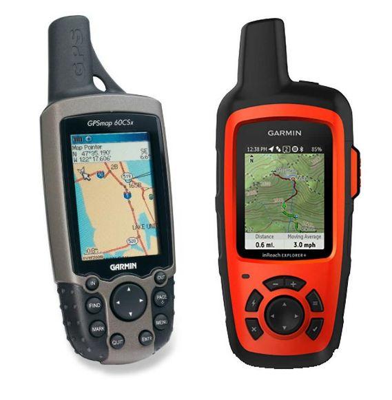
I read that the Explorer+ can handle the Birdseye Satellite Imagery. My 60CSx does not.
Hard to believe the Explorer+ would have less of a route import capability than the old school 60CSx. I have been trying to find a YouTube video of the Explorer+ tracking a route in map view. thanks again! -
3 hours ago, Oracle said:Ok, I can answer part of your question. Yes, the 60, 76 and 78 Garmin's have a 500 point per route max. With that said, you can upload any route, even routes over 500 points, into basecamp and convert them to 500 max point routs. Also of note, when you download some routes from the internet, for example all the BDR routes, you have a 500 point route option, so no need to convert those routes. The advantages to the older Garmins is they will automatically run the next closest route for you. So if you are following the BDR, which will include approximately 8 to 10 segements, once you complete a segment, the next one will start. I'm not sure if the newer Montanas do this??? Seems like they should but I do remember one person complaining that it didn't.
Amazing! I had never tried to convert the tracks from dualsportmaps to a route in Basecamp. I usually just split the tracks to avoid the Route Truncated error message.
I just gave it a try using Basecamp instructions here:
https://www8.garmin.com/manuals/webhelp/basecamppc/EN-US/GUID-AFF8D4EA-97EC-40BB-9651-EA0B7E0F9394.html -
That hikingguy Cris actually responded to my question:
You can import using the website and sync to your device but the experience won't be great. The route will just be a series of thousands of individual waypoints. You'd be better off with a different device for following a route unless you just want to look at the screen and see if you're on the track line.
Glad the site was helpful & have a good one!That is exactly what I do want to do... "just look at the screen and see if you're on the track line."
However, I would not want a long, curvy route to end up looking like a series of straight lines one mile apart. I can imagine if I split my track up into five different routes of 200 points each, it might be okay.
Still hoping to find someone who actually owns one and imports long routes. Thanks for the info guys!
-
I currently have a Garmin 60CSx and I can upload gpx tracks (from dualsportmaps, for example) as long as they are short and limited in number. It's a bit of a pain to split up the tracks, but it works. I have "heard" online that there is a 500 point max for uploading to the 60CSx. Not sure if that is true.
Now, I was looking at a Garmin Inreach Explorer+ for sat communication and also using it to replace my 60Csx. However, I have seen on the internet that when you upload a gpx track to the Explorer+, it must first be converted to a "route" and then the unit downgrades the the route to a max of 200 points. Is this true?
All I want to do is follow the blue line on trails and in Baja. I do not need to navigate to the closest starbucks. Will the Explorer+ work for this basic type of mapping, or is it going to be even worse than my 60CSx when it comes to importing a long gpx track? I though it would be cool to just hardwire the Explorer+ and use it as an all-in-one.
Does anybody own one of these who can give advice? Thanks!
-
Had a great ride today with a couple new riders. Coral Canyon outer loop and then Campo to Tecate along the fence. No issues with the friendly Border Patrol agents. Waves all the way. We ate lunch at Cafe 94, which is in the Twin Lakes RV resort in Potrero. It's a breakfast and lunch place (8am to 2pm) that had really good homemade soup. I was expecting rustic and dusty, but it's actually very nice, clean and laid back. Stopped at the Campo Motor Transport Museum on the way back (open Saturdays).

-
 2
2
-
-
I chatted with the Bivy Stick rep (live chat at 10:30pm). She said the monthly fee of $17.99 covers 10 credits. And the extra credit packs will be added to the website later at:
20 for 8.9950 for 19.99100 for 34.99Looks to me like they just launched the sales website. I kind of like the extra battery pack for the smartphone. -
-
-
-
Welcome! Look for noob rides posted here occasionally.
(And don't take your F800 down Heart Attack Hill) -
10 hours ago, CVRick said:I cannot get videos to play
Repost reboot on YouTube
-
I used one for the first time on a fellow rider a few months back. It had to be screwed onto the stem, and then the pressure released. One canister filled his rear tire to 10 psi.
-
4 hours ago, CVRick said:I cannot get videos to play
mmm... I wonder if you have to be logged into facebook?
-
11 minutes ago, Wierdrider said:Hah, up close and personal!
Hey David, are these on your YouTube channel?
Facebook but I will put them on YouTube too.
-
3 hours ago, Uncle Champ said:Hey TV Scum that's how I do HAHill too, just throw the bike down near the top and get it over with
")
How was the rest of the descent?
:-) Mark hiked down and talked me through the rest of it. Kick start XR flooded out and had to bump start it at the bottom. It was all good after that!
-
Thanks to Paul and Mark!
-
45 minutes ago, Pokey151 said:So I am in, I just dont have an air pump. I have spoons, tube patch kit but no air. I ordered a co2 but it's not due in until monday.
You'll be fine. I have extra co2, others probably will too.
-
Maintenance done. I'm in. Thanks for offering this up!

Upload gpx tracks to Inreach Explorer+?
in GPS Stuff
Posted
Reading a lot of Amazon reviews critical of the GPS capabilities and gpx import limits of the Inreach. Apparently, the inreach acts differently than other Garmin devices because Inreach was developed Delorme originally. So, there is no all-in-one option? I may as well go with a Garmin mini or a bivystick, which requires me to carry...
- 60Scx hardwired
- Satellite message device
- Iphone
- Backup battery charger
Thanks to all!