


tvscum
-
Content Count
1034 -
Joined
-
Last visited
Posts posted by tvscum
-
-
14 minutes ago, Bp619 said:Do you know why?
Closed due to unsafe road conditions per Forest Order No. 02-20-8
I hope to get more info soon.
-
Looks like the dirt section that splits off of the paved section of pine creek road north of the big tree is going to be closed for a year... AT LEAST. So, pavement only for pine creek?
https://www.fs.usda.gov/Internet/FSE_DOCUMENTS/fseprd737194.pdf
https://www.fs.usda.gov/detailfull/cleveland/alerts-notices/?cid=stelprdb5340229
-
-
Instagram photo... and a touching video behind the photo
-
-
18 minutes ago, Vintage Veloce said:That is 7PM UTC, which is Noon, Pacific time. The aircraft circling looks to have been centered about here: https://goo.gl/maps/Hg44uKkxCLYDxZXE9
On Google maps spot there is an satellite image seam directly over that area. Looks like one older satellite image right next to a newer one.
-
-
-
-
Watch channel 8 news. Lead story at 5 PM
-
1 hour ago, Guest Guest56 said:Was the bike near him ? Or has it been located at all?
Yes ridden out
-
Location is Dirt point offshoot at BLM gate
-
-
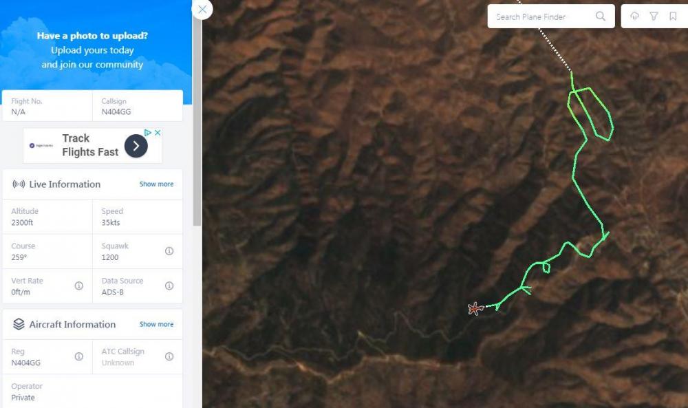
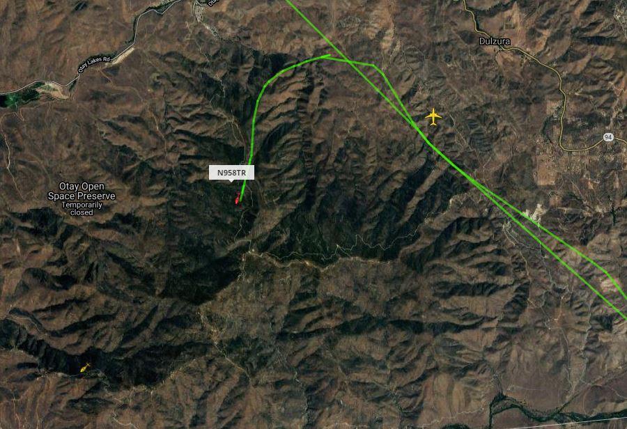
1 hour ago, tvscum said:Has someone has walked that gnarly hill above Mocogo Ranch house here:
https://www.google.com/maps/@32.6227194,-116.7919327,706a,35y,39.17t/data=!3m1!1e3
That is tough hill to descend and there are two routes.
Private helicopter just circled that hill.. no other chopper activity this morning so far.
https://planefinder.net/flight/N404GG
-
6 minutes ago, Guest Maribel said:Hello . My husband and I hikeD the sycamore Canyon yesterday. We are planning to go on our mountain bikes today . We know some people from Dulzura and know some of them covered some areas by the shooting range and the mountains around.
Has someone has walked that gnarly hill above Mocogo Ranch house here:
https://www.google.com/maps/@32.6227194,-116.7919327,706a,35y,39.17t/data=!3m1!1e3
That is tough hill to descend and there are two routes.
-
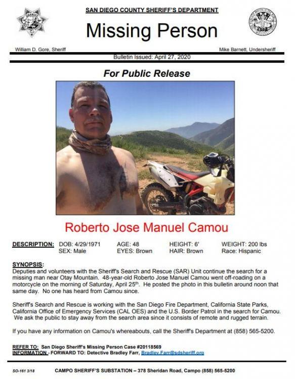
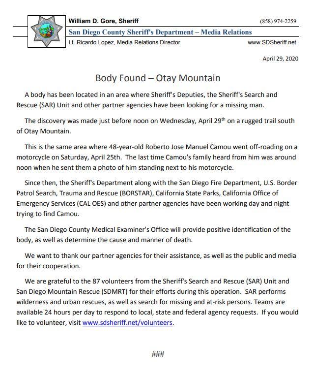
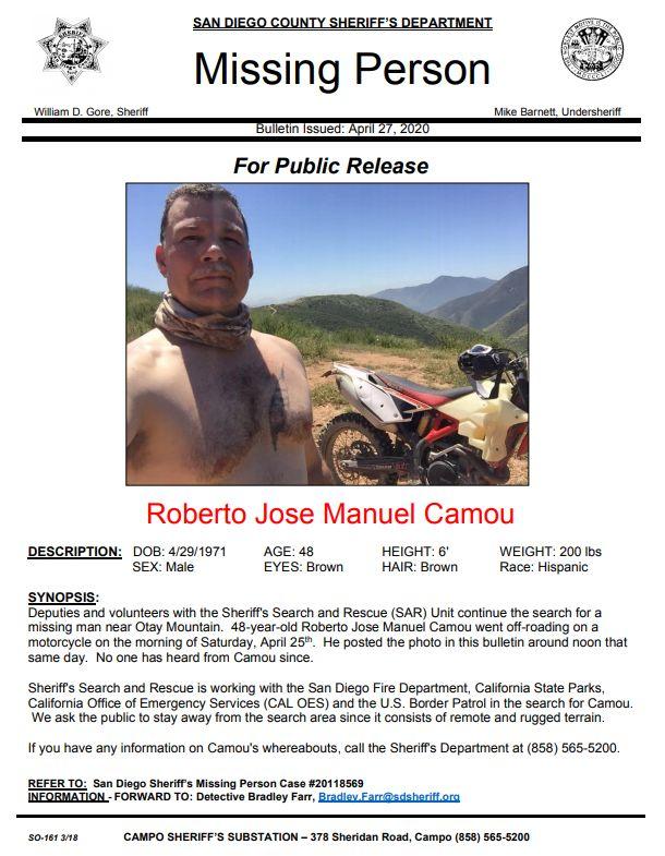
2 hours ago, ADV Bum said:Hi guys. The search continues. We are holding strong to our faith and have a positive attitude towards finding my dad. Please keep the prayers coming now more than ever. Anyone who wants to help our civilian volunteer crew, which contains expert level hikers can now just go through sheriffs who have my contact info. It is now too overwhelming to answer DMs and comments on FB, so again, call sheriffs if you want to help. I am out there personally in the dirt and brush screaming and searching for my dad. PLEASE listen and respect authorities and don’t try to go rogue, we are trying to be as organized and thorough as humanly possible. Don’t let curiosity keep you near search efforts, this will take up space and resources.
My dad is extremely resourceful and resilient. We believe he has the strength to make it out of this alive. Please send prayers. I miss him so much. We are a very close family and he texts me goodnight every night with a “😘” to make sure I’m safe. He served as a volunteer firefighter for Campo Fire Dept. several years back and has a heart that wants to help others. Helping others is his driving force and he would be out there just like all of you if it was your dad. My mom is in pieces over this as they are the best of friends. They love to laugh together and shower their rescue dog, Cricket, with kisses. Just trying to stay focused on bringing him home.
She deleted this post... not sure what that means. Glad you posted this because it reminds me he was a volunteer firefighter.
-
-
4 hours ago, tvscum said:Just posted on FB:
Deevinda Lee Tosten I called my son this morning to let him know I had seen a dirt bike rider come down a fire Road and then go back up it and I never saw him come back down again it was Saturday late afternoon my son posted the following comment on the Jamul page “Where does he live? My mom lives on Honey Springs and saw a lone rider head up one of the fire trails late in the afternoon and did not see him come down. Is it possible he lives near 4 corners and he would have been up there?” I don’t know if this is related but I thought it maybe helpful information. The fire road runs from Honey Springs rd to Barret at Lake
another one... FB
Adam Wing We saw a flashlight up on the hills up above Barrett Lake enterance tonight off Lyons Valley Rd, thought it was kind of odd, being that the lake is closed. I don't know if this was the area he could be in?
-
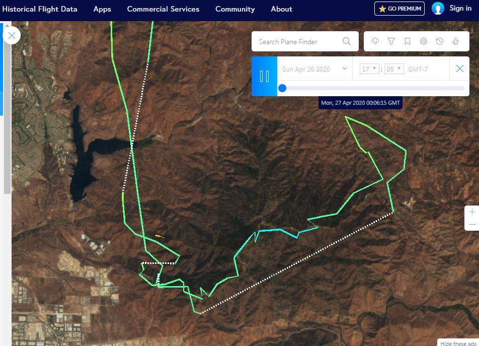
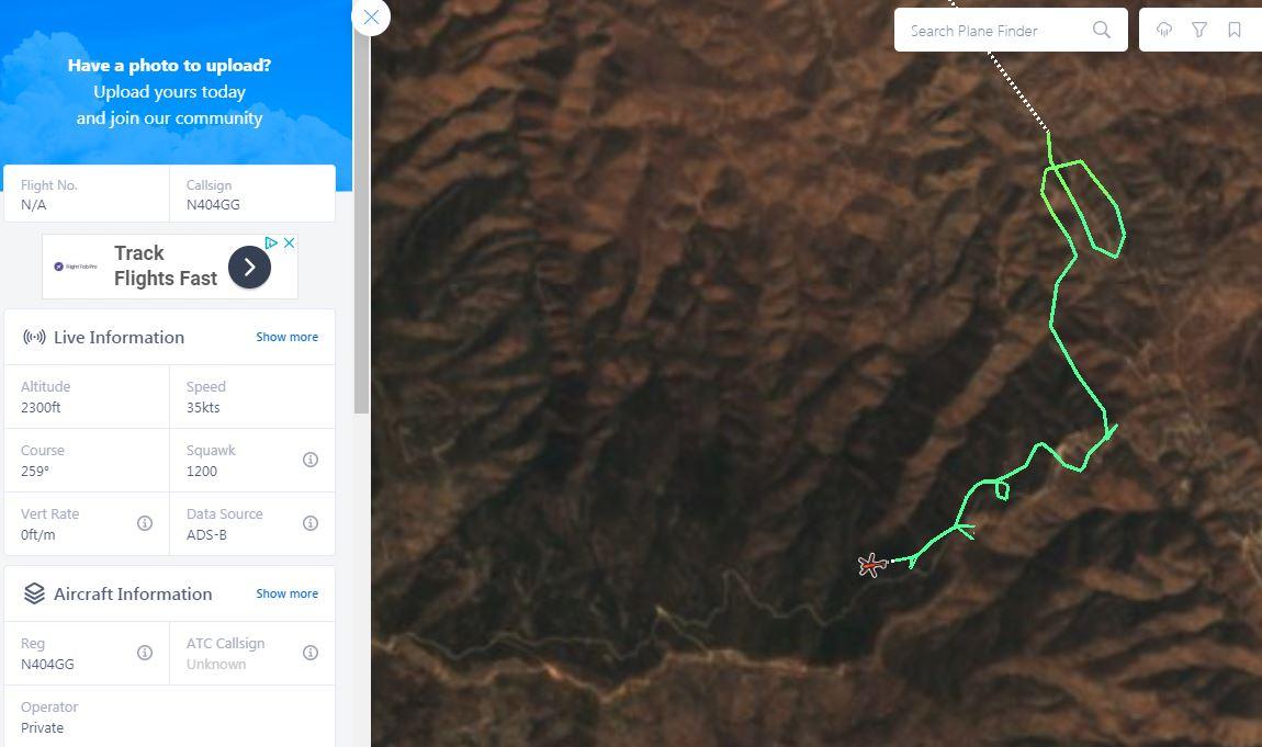
15 minutes ago, Guest BrianInSD said:Could you by chance screenshot the private choppers tracks from Sunday? Thanks.
Click on this link and zoom in... you have to select the latest track.. the dotted lines are where it dropped off radar
https://planefinder.net/flight/N34WH
-
Just posted on FB:
Deevinda Lee Tosten I called my son this morning to let him know I had seen a dirt bike rider come down a fire Road and then go back up it and I never saw him come back down again it was Saturday late afternoon my son posted the following comment on the Jamul page “Where does he live? My mom lives on Honey Springs and saw a lone rider head up one of the fire trails late in the afternoon and did not see him come down. Is it possible he lives near 4 corners and he would have been up there?” I don’t know if this is related but I thought it maybe helpful information. The fire road runs from Honey Springs rd to Barret at Lake
-
Finding him would be the best birthday present ever! (see DOB)
-
45 minutes ago, luna said:I have more intel, this is from 2 hours ago while a buddy was at the Pio Pico basecamp.
Just got the bike not too long go.
Has ridden maybe 4-5 times, each time solo. That is why we are not getting help from any riding buddies.
***disclaimer take this with a grain of salt, this what I've been told by a rider at Pio Pico at 11am at the basecamp. They aren't trusting the "Ping" location, so they want to look eastside of Otay Mtn again"**** I hate posting hearsay, but it's only info I got. So with that.
I'll be going today to help search at 3pm from Pio Pico. Advanced Riders Only in group I'm going with. We are taking our HAM radios.
Going to cover from Pio Pico Otay Mtn Trail to up to Towers then down East Otay Mtn Trail to Dulzura, then North towards Pink Gate, then heading back to Pio Pico. Covering north east side of Otay Mtn.
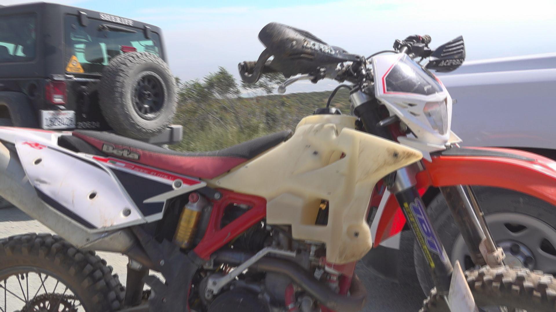
20 hours ago, Ken S said:Tough part about this. He’s riding a Beta 500 4 stroke with what appears to be a 4 gallon tank.
His wife told me all they had to go on was gps coordinates from a photo he sent them.
That was probably 1gallon of fuel into his ride.
Leaves a huge area of possibilities of where he could have gone.
I’ve ridden with Bobby and he’s a skilled and responsible rider. Not a newb.
Many prayers sent.Skilled rider or not?
-
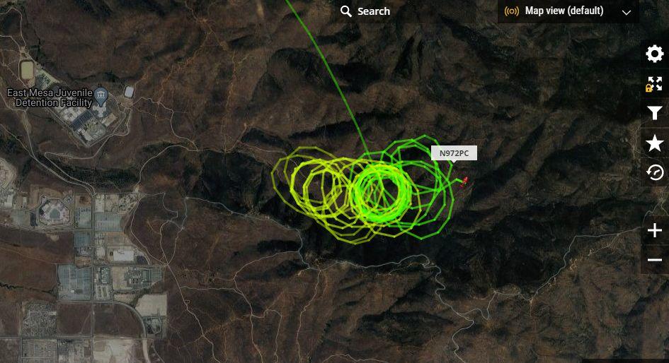
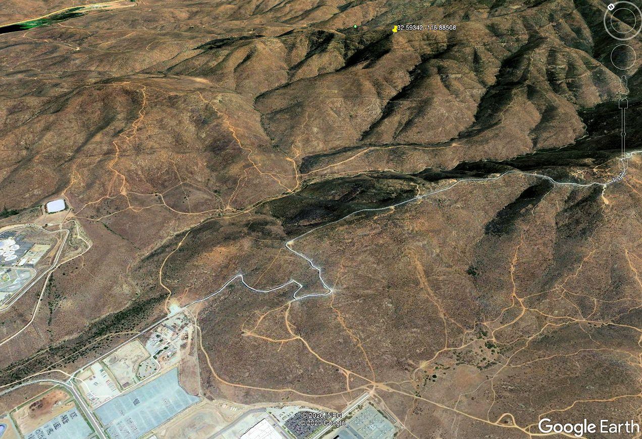
Better map:
https://www.flightradar24.com/N972PC/246986a0
This is the entrance area east of Alta Rd. The valley with those climbing hills.

-
Choppers are back after dark now... I assume using infrared cameras.
Sheriff
https://planefinder.net/flight/N972PC

Black Mtn Open - 5/17
in 1 to 3 Day Ride Write-Ups, Stories and Photos
Posted
Lots of riders, 4x4s, even saw a drone up there on Black Mountain Rd and Upper Santa Ysabel today. Went with a couple guys I grew up with in the neighborhood. All gates were open.