

tvscum
-
Content Count
1034 -
Joined
-
Last visited
Everything posted by tvscum
-
Lobster run - Sat 9/22/12
tvscum replied to Afry's topic in Baja Info, Upcoming Rides, Ride Reports, Photos, etc.
As long as the beer is cold, I'm okay. More info below: http://www.bajalife.com/bordercrossing/dininglobster.html Fresh vs. frozen: Most of the larger, more popular restaurants are owned or controlled by two families. This gives them the volume and ability to import live lobster from Baja California Sur and from as far away as Cancun during the months when local lobster is out of season. Smaller mom-and-pop operations are often forced to serve frozen lobster during this period. All of the restaurants we recommend serve fresh lobster year-round. Choosing a lobster: The most tender legal lobster is the medium size, weighing from 1 to 1* pounds. Restaurant owners will admit that anything over this is tough. While very small lobsters, often called "slippers," are delicious and extremely tender, they are illegal to catch, sell or serve at any time of year. -
Lobster run - Sat 9/22/12
tvscum replied to Afry's topic in Baja Info, Upcoming Rides, Ride Reports, Photos, etc.
I can't believe you can take a virtual street view tour of Puerto Nuevo on Google! Is no place safe? -
Lobster run - Sat 9/22/12
tvscum replied to Afry's topic in Baja Info, Upcoming Rides, Ride Reports, Photos, etc.
Nice photos from the Sierra ride on Facebook, I might add! So, it looks like this adventure tour company does a ride from SD down on pavement to Puerto Nuevo, then back to Tecate in the dirt. They describe the ride from PN to Tecate as 121 miles (that can't be right). Day 3 After breakfast we will leave the little village of Puerto Nuevo and begin our 121 mile ride to Tecate. With all those miles to cover, you better believe you will be getting a first rate view of the chapparal country side. We will ride through incredible valleys as we head inland on beautiful trails such as the Valle de Guadalupe and La Mision. The trail starts pretty rugged and rocky. As we get nearer to our final destination, notice how the rocks get smaller and smaller and eventually the rocks become sand. Enjoy these sandy trails and breathtaking views before we arrive at our beautifully secluded Hacienda hotel close to Tecate. What a ride! Now that we arrived at the final location you can choose how to spend the rest of the day. Here, in the outskirts of Tecate you won’t find a paved road around for miles. Enjoy the peace that it can bring. You may choose to freshen up and relax poolside. Or, if you still have the energy and would prefer to keep up the momentum we can begin to explore the trails in the area. We will end the day with a dinner at the hotel. http://www.letsatv.com/tours/destination-baja-ride/ They have some photos posted in the gallary, but not sure which photos apply to the Puerto Nuevo ride: http://www.letsatv.com/gallery/ -
Lobster run - Sat 9/22/12
tvscum replied to Afry's topic in Baja Info, Upcoming Rides, Ride Reports, Photos, etc.
Could be fun. I have new tires, extra tubes and I'm slimed inside. Anybody up for like posting a map? -
Lobster Run -Sun 4/29
tvscum replied to kkug's topic in Baja Info, Upcoming Rides, Ride Reports, Photos, etc.
What would be the suggetsted route? Percentage of off road? Big bike friendly? Overnight or down and back? It only looks about 45 miles from Tecate to Puerto Nuevo (by pavement). -
Lobster Run -Sun 4/29
tvscum replied to kkug's topic in Baja Info, Upcoming Rides, Ride Reports, Photos, etc.
Let me know when this is happening. What is the route? Is this an overnight or just Lobster and back? Bringing back memories old times back in the 80s. But I won't be taking my Scrambler through the Cantamar dunes. -
Good Sunday Ride 12 - 2 = 10, + 2
tvscum replied to TrophyHunter's topic in 1 to 3 Day Ride Write-Ups, Stories and Photos
I resemble that remark! It is NOT a sissy bar. It's a Ventura rack. The larger bar that holds the big bag is removable. -
Good Sunday Ride 12 - 2 = 10, + 2
tvscum replied to TrophyHunter's topic in 1 to 3 Day Ride Write-Ups, Stories and Photos
Great ride Ken! Thanks for planning. Enjoyed the burgers and beer at Brody's. Cheers! -
Sunday June 24 - Jamul - Otay - Mother Grundy
tvscum replied to TrophyHunter's topic in Informal Local Rides & Who's Going Riding!
What he said. The official map is on the first post. I just tried to trace it into dualsportmaps.com in case you have that app for your Android phone. See you in the morning! -
Sunday June 24 - Jamul - Otay - Mother Grundy
tvscum replied to TrophyHunter's topic in Informal Local Rides & Who's Going Riding!
I'd like to join you guys if that's okay. Tried to make a dual sport map for those of you who use that app. I am not the best at linking all the segments: http://www.dualsportmaps.com/?link=104831 -
Julian to Lake Cuyamaca to Descanso
tvscum posted a topic in 1 to 3 Day Ride Write-Ups, Stories and Photos
Took a solo ride today. Started out near Julian, went south on Pine Hills Rd to Eagle Peak Rd. Stayed on Eagle Peak all the way to the end, where the kids park their cars to walk down to Devil's Punchbowl. I thought I was going to to have to turn around and go back up, but a couple guys in uniform told me to take Forest Road 13S11 (aka Cedar Creek Rd.), which was open and took me back over to Boulder Creek Rd. at the spot where everybody parks at the trail head to Three Sisters Falls. I saw a Honda XR (I think) and a KTM riding 13S11 along the way. I took a left on Boulder Creek Rd. and headed over to Cuyamaca Lake on Engineers Road. That is a fun road, paved and windy. Ate lunch at the Lake and took 79 all the way south to I-8. Nice ride on and off pavement. I have done the entire Boulder Creek Rd. run in the past from Julian to Descanso, so this was kind of fun to mix it up. See info below. Cleveland map showing Forest Road 13S11. 13S11 is not shown on Google maps. http://www.fs.usda.gov/Internet/FSE_MEDIA/stelprdb5276625.pdf Dualsportmaps of the route I took: http://dualsportmaps.com/?link=104469 Photos of Forest Road 13S11 (aka Cedar Creek Rd): Engineers Road on the way to Cuyamaca Lake: Cuyamaca Lake for lunch: -
Big Bike ride and camping trip May 5th and 6th
tvscum replied to X-country-Rider's topic in Informal Local Rides & Who's Going Riding!
I'm not sure about the stretch of Apple Canyon Rd. to Bonita Vista Rd. to May Valley Rd. There may be locked gates. See San Jacinto Mountains motor vehicle map here: http://www.fs.usda.gov/Internet/FSE_DOCUMENTS/stelprdb5202572.pdf It shows May Valley Rd. stopping. I have not been down May Valley Rd. for 30 years. Once rode a horse down it. Maybe the Ranger station would know. -
Big Bike ride and camping trip May 5th and 6th
tvscum replied to X-country-Rider's topic in Informal Local Rides & Who's Going Riding!
Its a family trip in the truck. Headed up around noon from Pine Valley. Have fun up there! -
Big Bike ride and camping trip May 5th and 6th
tvscum replied to X-country-Rider's topic in Informal Local Rides & Who's Going Riding!
I'm headed to Idyllwild on Saturday maybe i can take pictures of Thomas Mountain Camp ground. What's your itinerary for Idyllwild tomorrow? -
Big Bike ride and camping trip May 5th and 6th
tvscum replied to X-country-Rider's topic in Informal Local Rides & Who's Going Riding!
If you get up into Idyllwild, there are a couple of out-and-back trails listed on the motor vehicle use map that are pretty scenic (at least they were 30 years ago!). May Valley Rd. (5S21) and S. Ridge Trail (5S11 to 5S11B). -
Big Bike ride and camping trip May 5th and 6th
tvscum replied to X-country-Rider's topic in Informal Local Rides & Who's Going Riding!
Nice job! Thanks for setting this up. You no longer owe me two zip ties. -
Big Bike ride and camping trip May 5th and 6th
tvscum replied to X-country-Rider's topic in Informal Local Rides & Who's Going Riding!
Motorcycles allowed in site 1-7 only, no more than six occupants and two vehicles per site, according to this brochure on Hurkey Creek. Looks like all the motocycle sites are taken too. http://www.rivcoparks.org/wp-content/uploads/Hurkey-Brochure.pdf EDIT: Sorry, i missed the note about the group sites. I assume those are okay for motorcycles? -
Scouting ride April 7th
tvscum replied to X-country-Rider's topic in Informal Local Rides & Who's Going Riding!
Nice ride! Love your "street legal" ride. See you guys May 5th. Hey, where is that GoPro video? -
Solo ride Saturday up Lawson Valley Rd. Stopped and spoke to a friendly lady on a horse who gave me directions. I took a right on Rudnick Dr., then another right on Mark Lee Dr, which leads up to Wisecarver Ln. The bottom gate was open. The upper gate at Wisecarver was locked, however... Then I took Lyons Valley Rd. to Japatul Valley Rd. all the way up to Hwy. 8. Then went old Hwy 80 and took Pine Creek Rd. Man that is a nice road! I have never ridden it before. Saw some mountain bikers and vehicles stopped. Everyone was super nice and waved. I had to turn around because it was getting dark. I'm looking forward to riding Pine Creek all the way on the hijinks ride May 5. I just registered online and am excited to be meeting some of you guys. Pine Creek Rd photos:
-
Lawson Valley to Pine Creek
tvscum replied to tvscum's topic in 1 to 3 Day Ride Write-Ups, Stories and Photos
You are my conscience Ken. I do many rides in Southern Utah and the North Rim of the Grand Canyon and don't post the rides because I don't want to publicise the areas that are already over used. Just came back yesterday from a weekend in Page and riding. But I have to admit that I enjoy other riders posts of their rides, especially the photos. Thanks for making me feel guilty. Kudos to Randy and SDAR. Yeah, well the secret of Pine Creek Rd. will be out of the bag when, what?, 50 dual sporters ride on up that trail on May 5th on the Hijinks ride. Ya hooooooooooooo, I just got Monday May 7th off work too! That means I can pound the dirt in Idyllwild on Monday before heading home. I went to boarding high school in Idyllwild 1978 to 1980. I am thinking of reliving the old trails up there (back when Southern Comfort was all the rage). Probably need an adventure pass, but I am wondering if anybody knows the status of May Valley Rd. or South Ridge Trail up to the "reflector" as possible dual sport riding roads? -
Lawson Valley to Pine Creek
tvscum replied to tvscum's topic in 1 to 3 Day Ride Write-Ups, Stories and Photos
Cool I will check that out. My wife might be better off with that. Cheers! -
Lawson Valley to Pine Creek
tvscum replied to tvscum's topic in 1 to 3 Day Ride Write-Ups, Stories and Photos
Looking forward to it! I'm a Stone brew fan and it looks like some similar product is fermenting. My wife is going to transport the camping gear down to Butterfield, so I won't be too weighted down. I'll be installing a center stand before the run, just in case. I'm also waiting for some Ventura racks. Should be fun! -
Lusardi Truck Trail
tvscum replied to karlaeda's topic in 1 to 3 Day Ride Write-Ups, Stories and Photos
I have never been up Lusardi Truck Trail. (I have been on Black Canyon Rd.) So, you can take Lusardi TT all the way north to Mesa TT (looking at google here). And, then what? Can you take a left on Mesa TT and go all the way to Hwy 79? Or do you have to take a right on Mesa TT and go to Mesa Grande Rd to get out? -
I took my Scrambler up and over Otay Mountain Truck Trail today, starting off at Otay Lakes Rd and exiting near Donovan State Prison. I actually ran into a guy doing the same run on Vespa scooter, wearing a British flag helmet! FYI, there is a locked gate at the bottom exit point to Alta Rd. We managed to get out but it was not easy. I think the better way out is cut off the Truck Trial toward the end and exit the paved road that runs just north of that huge power plant. We did not take that road, though, and I'm not 100% sure that's an easy way out. I did see some Border Patrol trucks going up that road though. Does anybody know the best way out of there? Near the summit looking into Mexico: And looking west over Otay Lakes: A couple dual sport bikes in the distance:
-
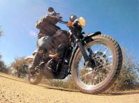
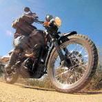
Hey guys, I know I am entering the land of BMWs and KTMs, but I just purchased a 2012 Triumph Scrambler and I am looking forward to hitting the dirt! I upgraded the suspension front and rear. Now, I am slowly working my way back into the backcountry roads of San Diego, after more than 20 years. In the 1980s, I used to ride enduro thumpers (see bike history in my signature) in San Diego and Baja. Now in my late 40s, I commute to work daily on my Scram. I am hoping to ride with some of you dual sporters on the weekends. Nothing too technical because this Scrambler is about a 500 lb bike. The travel on the suspension is also pretty short. Still, it can handle some mellow truck trails. My Scram recently made a cameo appearance in this News 8 video report here in San Diego. See the Boulder Creek Rd. bonus video. See you on the trails! Adventure trails offer legal, off-road fun in San Diego’s backcountry http://www.cbs8.com/story/17005120/adventure-trails-offer-legal-off-road-fun-in-san-diegos-backcountry