

tvscum
-
Content Count
1035 -
Joined
-
Last visited
Everything posted by tvscum
-
Anybody up for a Sunday May 5 ride - Rouse Ridge and Toro Peak
tvscum replied to Little Bike's topic in Informal Local Rides & Who's Going Riding!
Not going to make this one. Thinking about a Saturday ride instead, but not sure where. -
Here's the cheap mount, $15. Motion-X app is 99 cents. I have no power cable but I might order one of those USB battery backups seen here: http://www.amazon.com/gp/product/B009OYSIVQ/ref=oh_details_o00_s00_i00?ie=UTF8&psc=1
-
2 day Baja lobster run in June
tvscum replied to Afry's topic in Informal Local Rides & Who's Going Riding!
Sounds like fun! Let me check my social calendar. Oh, and I have to decide which bike to ride... -
I found the listings here to be fairly accurate http://www.fs.usda.gov/detailfull/cleveland/alerts-notices/?cid=stelprdb5340229
-
Anybody up for a Sunday May 5 ride - Rouse Ridge and Toro Peak
tvscum replied to Little Bike's topic in Informal Local Rides & Who's Going Riding!
Lurking... what time will you guys be passing by Paradise Valley Cafe (Garner Valley) at the intersection of 74 and 371 on your way to the Toro Peak turn off? Could be a couple hundred miles round trip from Tierrasanta. http://dualsportmaps.com/?link=109717 -
Anybody up for a Sunday May 5 ride - Rouse Ridge and Toro Peak
tvscum replied to Little Bike's topic in Informal Local Rides & Who's Going Riding!
What's the trail that takes you down from Anza to Warner springs? Arnie? -
I ordered this really cheap mount because it covers the device, and I don't want to have to remove my belt holder frame from the phone every time I use it for a GPS. http://www.amazon.com/Arkon-GPS032-Handlebar-Mount-3-5/dp/B003FMUP0K/ref=sr_1_1?ie=UTF8&qid=1367425311&sr=8-1&keywords=Arkon+GPS032+Handlebar+Mount+for+3.5+-+4.3-Inch+GPS+Devices I have been able to import .gpx files the same way using MotionX by emailing the file to myself. As far as I can tell, the app will not auto cache the track, though, like the dualsportmaps android app does. MotionX will only cache an area of the map that you can define by dragging a circle over the general area, which means a lot more tiles have to be cached. What I would really like is an app that will auto cache the track using a hybrid-satellite base map so that you can see the dirt roads. I guess with MotionX you can manually trace the track with the hybrid-satellite base map and it will keep the cache for offline use. But it's a pain to cache all zoom levels of the tiles when doing it manually. But you get what you pay for!
-
Led Zeppelin rode Enduros..
tvscum replied to SCHWINN's topic in A Forum for GENERAL PHOTOS & Videos
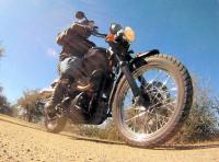
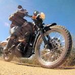
I am led to believe this photo was taken as part of a press tour in 1972, as a caption I found reads: "February 1972 Led Zeppelin riding motorbikes at Frenchs Forest in Sydney" And the following press report: The Led Zeppelin concert at the showgrounds last Sunday must rate as one of the best ever held in Sydney - but, if the crowd had not stormed the fences, it could have been the worst. The official attendance figure was 27,000 but senior police officers at the concert estimated the crowd at "at least 30,000". According to showground officials the three stands used last Sunday have a maximum capacity of 25,000 - so whatever way you look at it the ground was dangerously overcrowded. Despite the fact that there were no seats left at mid-day and no standing room by 1.30pm., people were still coming through the gates at 2.30pm. The overcrowding that existed before the fences were stormed must never be allowed to occur again because next time someone could be killed in the crush. Once capacity is reached the gates should be closed. David D. Bryant The Sun-Herald, 5 March 1972, p. 109. And 8mm footage from the concert in Sydney: -
Led Zeppelin rode Enduros..
tvscum replied to SCHWINN's topic in A Forum for GENERAL PHOTOS & Videos
Mellow is the man Who knows what he's been missing Many many men Can't see the open road. -
Going with Motion X GPS. It was a difficult decision but I decided to take the plunge and drop 99 cents on the app. http://gps.motionx.com/iphone/overview/
-
Led Zeppelin rode Enduros..
tvscum replied to SCHWINN's topic in A Forum for GENERAL PHOTOS & Videos
Hangman, hangman, upon your face a smile, Pray tell me that I'm free to ride, Ride for many mile, mile, mile. -
Took a solo ride dowm memory lane today, where I grew up as a kid. Found the secret garden that was still green. The spring is fading fast from green to brown, though.
-
I plead ignorance. No signs or gates on the route I took.
-
San Diego
-
Thanks for the link! The important thing is to be able to cache tiles for use out of cell phone range (and probably in airplane mode to save battery power).
-
I did a solo ride along the border fence from Otay to Barrett Junction Sunday. I passed about 20 border patrol agents and they all waved. One stopped and helped me with directions regarding an alternate route to Barrett. Then, this morning, I read this article on border agents "Sign Cutting" -- basically tracking immigrant footprints to determine which ones got away. I actually saw an agent on foot who looked like he was doing some tracking and he had a friendly wave for me, too. I wondered if my off-roading along the border fence might mess with this effort? I hardly ever put my feet down -- except at the 250 marker -- so maybe not. The agents didn't seem to care either way. http://www.cbs8.com/story/22036592/under-pressure-border-patrol-now-counts-getaways
-
Thanks for the info guys. Glad I stirred up some dirt and stayed on this side of the fence.
-
Bruce & the Young Guns Do Baja
tvscum replied to Goofy Footer's topic in 1 to 3 Day Ride Write-Ups, Stories and Photos
Goofy, do you carry ANY gear? -
There is a Heaven....and it is orange
tvscum replied to Afry's topic in A Forum for GENERAL PHOTOS & Videos
There's only 28. I'll take one please. -
Crazy thrashment of a Scrambler. Looks to be all stock.
-
New Scrambler off road video
tvscum replied to tvscum's topic in A Forum for GENERAL PHOTOS & Videos
Note: no rocks or sand in that video! -
-
My buddy trucked my XR440 along with his CRF450X out to Borrego Springs today, where some old buddies of ours were camped out with their toys for three days. We didn't take any photos of our dirt bike treks, but we had the chance to thrash a couple of these Razor 900s. OMG, if you have never driven one of these you are in for a great time! These things go anywhere! They are 4 wheel drive automatics. If you get into a slide, just hit the gas and the front tires pull you out. Man, it was a treat to drive one of these things. If I had the money, I would buy one for my wife to drive as chase truck! I'll add one to the list.
-
Ocotillo Wells ride
tvscum replied to Slaugo's topic in 1 to 3 Day Ride Write-Ups, Stories and Photos
Hey Kato, what's that GPS mapping program you're using? -
Awesome bike! Looking forward to seeing it in action! But that year in your signature can't be right, can it (1994)? I thought 1996 was the first year for the XR400. No?