

amgems
-
Content Count
869 -
Joined
-
Last visited
Posts posted by amgems
-
-
3 hours ago, DSM8 said:Locus Maps with brouter for offline maps.
I can't see where Locus Maps provides offline satellite maps. Looks like they have street, topo, terrain, etc. but not seeing satellite.
-
Normally those things are like $700. Hmmmm?
Maybe it isn't programmed?
I've run JD Tuners on all my FI KTM's. They work great for fixing the fueling issues.
-
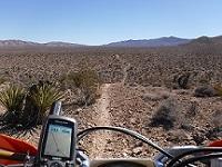
In some of the areas I've been riding here in Az the roads and trails actually exist but don't show up on street, trail, or MVUM type maps (printed, Garmin, or those available in phone apps). Being able to look at a zoomed in satellite view would be helpful to determine if the road or trail goes thru, connects, etc. Very often there is no cell service, so can't just pull up Google Maps in satellite view.
-
3 hours ago, DSM8 said:the combination or Locus Maps and Router on an android phone has worked very well for me.
Need to know few things like:
- What OS are you wanting the app to run on
-
Is this going to be a smart phone dedicated to GPS use or used both as a phone and GPS
- e.g. will it be connected to a cellular network
- Or are you looking to run something else?
Running on android.
Smart phone dedicated to gps use.
Running in airplane mode. No network access.
-
Thanks Udo, Does "Here" have satellite maps? I can't seem to find them. Looks like only street maps. Might be me.
-
I would have called the cops.
-
Which phone based apps have offline satellite maps?
Looks like Gaia has it, but only in the $40/yr package.
A lot of the apps I've checked out are not clear if they offer this
I'm playing with downloading Google satellite maps (for offline use while out on the trail), but it seems like either the resolution is not high or I'm trying to download too big an area. Any tips, advice?
-
Which phone based apps have offline satellite maps?
Looks like Gaia has it, but only in the $40/yr package. Too much, I'm cheap.
I'm playing with downloading Google satellite maps (for offline use while out on the trail), but it seems like either the resolution is not high or I'm trying to download too big an area. Any tips, advice?
-
About a week ago Zach came by the house in the morning and we took a ride out of Camp Verde up onto the Mogollon (pronounced mug-ee-yun) Rim. A lot cooler at 7000 ft. than it is at 3000 ft in Camp Verde. We rode to The T-Bar Ranch Cabin in the Coconino National Forest. Very cool old cabin. I would guess built in the 1920's ? Could not find any history online. Just some photos. We met some equestrians from Phoenix area that were camping near there. After the cabin we rode up to Apache Maid Mountain. The road was closed near the top. Probably because it was the start of a 3 day weekend and the Forest Service didn't need to deal with crowds. At the gate we met Charles. He rode with us back down into the Verde Valley. I missed some of the ride on the video, but got a good part of it recorded. About a 70 mile loop. Mucho fun. Click the little gear bottom right and set to 1080 for better resolution.
-
 1
1
-
-
On 5/24/2020 at 4:02 PM, hobiee said:Get a Road ID. Never leave home without it, mine is a bracelet type but there are many.
https://www.roadid.com/?referrer=60640&gclid=EAIaIQobChMI5fiDmJLQ6QIVoRx9Ch3wKwELEAAYASAAEgLNvfD_BwE
-
1 hour ago, Wierdrider said:Pro Moto makes a good rack too I think?
Yep...Pro Moto Billet - Fastway racks are very strong and very expensive...but you get what you pay for. I have had 2 so far on my last 2 bikes. They are indestructible. I have one now on my 2018 KTM 500 EXC-F it is just as good as the last two I've had. Also have one of their kickstands that CID is talking about. Very strong.
I think this is their rack for your bike https://fastway.zone/product/pmb-01-3209-g/
Congrats on the new bike. I find my 500 to be a very versatile bike.
-
On 5/12/2020 at 8:12 AM, Oracle said:I've got approx 1000 miles of riding since the lights on my Spot3 started blinking red in early March. I carry two sets of back up AAA batteries. The point being, there is significant life left in the batteries even when the Spot starts blinking red.
Wow! That's good to know. I put fresh batteries in right away. I also fill up my gas tank when it is 1/2 full. LB, I'll bet you don't fill up until it is below empty. 😀
-
Casner Mountain Road. About 170 mile loop. Very nice views.
Casner Mountain Road AZ - Dual Sport Ride - About 170 mile long loop from Camp Verde, to Cottonwood, hooked up with Zach there, then, thru Sedona, almost to Flagstaff, and then down Casner Mt Rd back down into Cottonwood and back to Camp Verde. We weren't sure if we wanted to go up Casner or down. I'm glad we went down. Very steep and rocky. Having some fun playing with the video editor on this one. Got almost all of it recorded, but the battery in the GoPro died at the top of the switchbacks that go back down into the Verde Valley. You'll just have to imagine it (think steep and rocky thoughts while picturing it in your head).
-
2
-
-
A few weeks ago did a 120 mile loop. When I fired up the SPOT all the lights were green. When I got home Power and GPS lights were blinking red. I thought maybe the batteries had quit during the ride, and my tracking did not work or wasn't complete. Went to my tracking page and the whole ride was tracked. Batteries read about 1.3 volts. Spot gives a pretty good warning when the batteries are starting to die. I checked device status and it looks like the batteries hit "weak" status right after I started the ride. So they lasted at approx 4-6 hours in a low voltage condition and kept transmitting my location. Thought you guys might like to know.
-
1
-
-
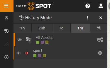
If you click on the little "clock" (History mode) in the left side sidebar you can select a number of different time frames
-
1
-
-
I have the link to my SPOT Tracking page. https://maps.findmespot.com/s/MKTX on my profile page here. I think you guys can see it?
May not do me a lot of good now a days sharing it with my SD riding friends, being out here in the middle of Arizona, (but ya never know), might be a good idea if those of us that have SPOT , INREACH or other emergency devices that have a tracking feature, provide those links to our riding buddies and other people that might care about you (however slightly). I send an email out every so often with the link address to my wife, sister in law, sons, riding partners, probation officer, etc. just to remind them it exists.
If I don't show up back home on time it is easy for Mrs Amgems to look at the tracking info and see if I've been in the same location for a long time. I could be hurt and unable to hit the HELP or SOS button. Or parked in front of some tavern somewhere. Either way she could locate me. Hmmmm?
The SPOT page was upgraded a few month ago. So if you have an old link, good idea to check it out and update the address if needed. The new link is better. You can better select the time frame of locating pings now.
-
2
-
-
16 minutes ago, Bagstr said:This is the best bit of intel I have learned from this discussion; the custom bend on the rear supports. Those of us with Non-Macho vehicles have a dragging issue with the extra length off the bumper. The shown angle should help. I wonder if Joe can bend my straight unit?
You can bend it yourself. Find the right driveway. Ha ha. Joe or another welder/fabricator could cut it at an angle and re-weld it. That would be better than bending it. He also makes some with a "step" at the hitch end to raise them up. He could probably mod yours.
I have one of these on my Joe Hauler. No rocking with this. https://www.roadmasterinc.com/products/accessories/hitch/quiet.php
-
Thanks Randy
I'm still playing around with Prescott NF MVUM, trying to get 'em on the Montana. I'm getting closer with your help. Appreciate it.
They are pretty big. I will try some small tests next.
I've got the time right now....
-
I've already got one of these in my Garmin directory on my Montana 610.
I'm not so sure about this...
I've read that you can just rename a new gmapsupp.img to gmapsupp1.img or gmapsupp2.img etc. and add it to that same directory.
Is this true? Safe to do?
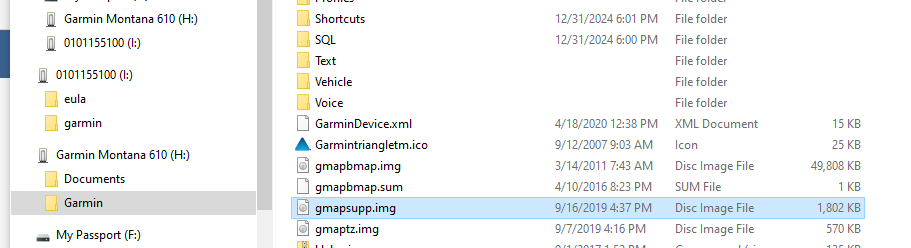
Also have one in (I) garmin directory on the unit. I think this is City Navigator on the SD card.
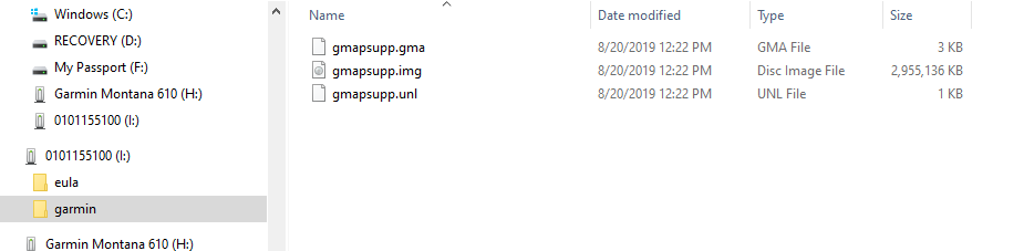
Can I add additional gmapsupp.img files without screwing things up, and, if so, where should they go?
Thanks
-
Garmin has a product called BirdsEye Imagery. I have not tried it, so can't comment on how good or bad it is. You buy a subscription and it will download satellite imagery to Base Camp and, I believe, your GPS unit.
-
14 hours ago, Goofy Footer said:Racers Machine must be a good spot.
What is a reasonable ballpark range for a shop to measure a cylinder / clean it up for routine top end rebuild?
Also installing new valves on a 4 stroke head?
A coworker of mine is trying to price out a rebuild.
It depends...Old bike...New bike... Just to measure cylinder and piston would not be too expensive. The new nikasil cyclinders do not wear too much. A good shop like this can measure the parts and see if you need a new piston, just rings, cylinder re-plate, etc. Many times with nikasil just rings can be replaced. But, you do need an accurate measurement to determine that. Wild guess...about $30 to measure. If re-plate is needed the cylinder has to sent to shops that do that. Only a few do it back in the mid west.
If you have a cast iron cylinder like Mr Jaja, They will need the piston so the bore can be sized to match. Usually with cast iron cylinder, it is at the least, honed and new rings used. At the worst case bored and a new over size piston and rings used.
With the head it can vary as well, depending on how much work is needed. It will need to be inspected / measured. Another wild guess for just inspection and measurement of head, maybe $50
Best bet would be to call 'em. I may be way off.
-
-
9 hours ago, luna said:You'll have to check, but this is off GAIA website. https://www.gaiagps.com/maps/offroad/usfs-mvum/
I know you can convert .pdf to .jpeg and reference to put in an APP navigational map. https://advrider.com/f/threads/converting-mvum-map-to-referenced-mvum-map.1360869/
Lot's of popular APPS are free GAIA, Locus Map, etc, just download another one on your phone try it out.
No one I know uses that app. Sorry I can't help more.
For all Avenza questions, your best bet is to search here. It's where I got all my info I needed on maps and APPS and how to use them.https://advrider.com/f/forums/mapping-navigation.37/
8 hours ago, PbdBlue said:Just as an aside you can get many MVUM's in GPX format for free here:
And easily converted to Garmin compatible maps with Javawa ImgFromGPX ( http://www.javawa.nl/imgfromgpx_en.html ). I'm assuming there must be similar options available for phone app users.
Thanks guys. This is very helpful.
-
It's quite a bit different here in Yavapai County. Something like 40 cases county wide. 1 hospital bed out of 300 occupied by a Covid patient. The hospital and emergency room in Cottonwood is unusually empty. I gotta run, I hear there is toilet paper down at the grocery store.
-
1
-
Offline Satellite Maps
in GPS Stuff
Posted
I'll have to keep messing around with the offline Google satellite maps some more. Or pony up for the paid programs that have 'em. Thanks for the feedback.