

amgems
-
Content Count
869 -
Joined
-
Last visited
Posts posted by amgems
-
-
That's good. I would have put it on upside down.
-
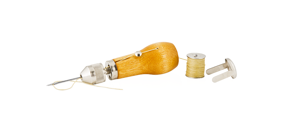
This is my favorite new tool. I used it to repair my back pack. I did a way better job than the seamstress did. It was so much fun to use, now I look around for stuff to fix. Very good instructions on their web site. Maybe it could be used on your zipper.
-
Mr. Bagstr,
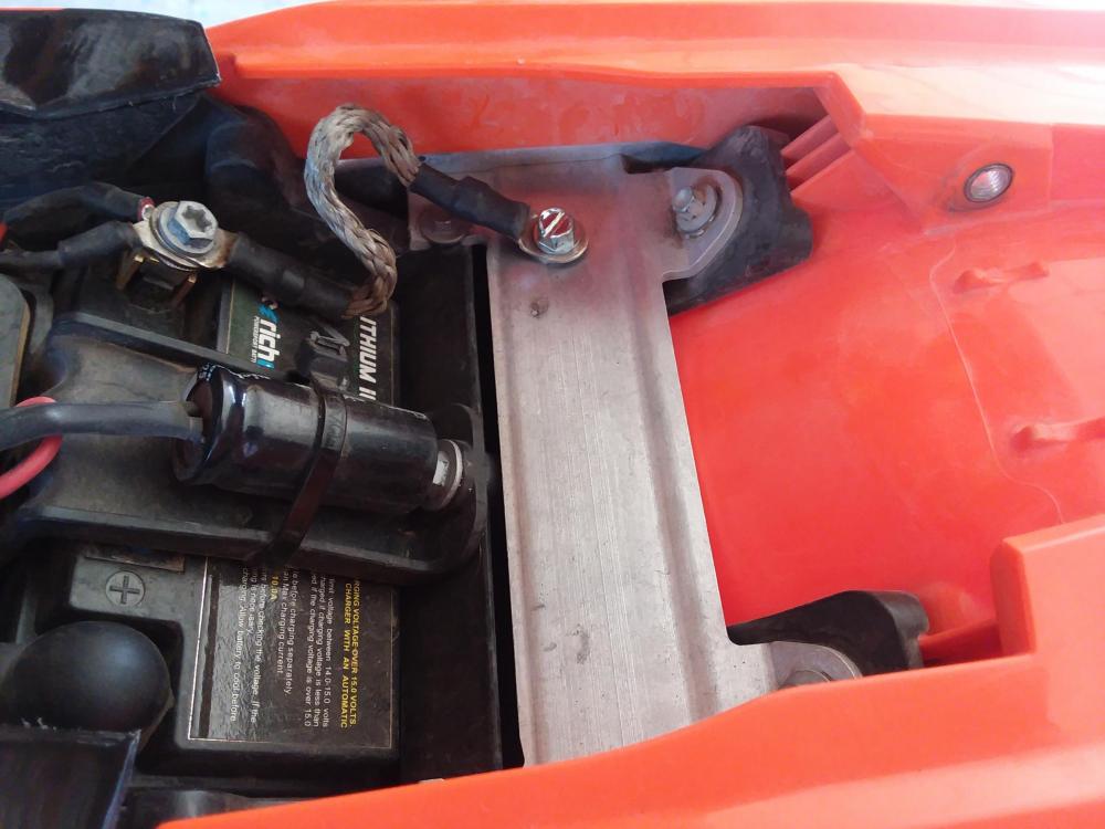
I thought about drilling and tapping the hole and using a machine screw. I went with a sheet metal screw with the thinking that the coarse deeper threads would bite better into the thin soft aluminum better than the fine shallow threads on a machine screw. It did bite really well and I was able to snug it up nicely. Way better than the original screw into the plastic (sheesh how dumb). I will keep an eye on it, and the hole is small enough that I could go up a screw size or two if I do need to switch. I would also like to say, thank you for keeping this conversation properly formal.
Mr. Amgems
-
KTM riders - Check your ground straps! My bike died Friday. Just completed a 75 mile loop. It quit 2 miles from home. Bike just stopped running. It would start with the kicker and run for a few seconds then quit. It would not do anything with the electric start button. Pulled the seat and realized I had not yet fixed the crappy ground wire attachment setup that was provided by the brilliant Austrian engineers on my $10,000 motorcycle. The screw that attached the ground strap to the frame was really loose. My theory is, because it was hot, the screw, that was screwed into the hot soft plastic fender came loose. Pretty weak design. The one on the other side was loose too. Fixed it with a beefy sheet metal screw.
-
Great article. Thanks!
-
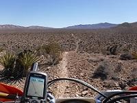
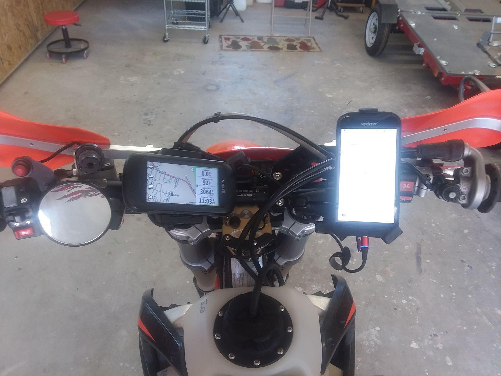
I thought I would update you guys on my experience so far using a mobile phone and apps for GPS navigation. First, thanks to all the other guys that posted here and helped me a bunch in getting going again with this! I've ridden about 300 miles or so using the DuraForcePro, Gaia Premium, Avenza and Locus Pro. So far as the actual app goes, Gaia worked out best for me. Also occasionally using Avenza for it's display of the PDF MVUM maps. Many of the other apps have a huge library of maps and the capability to use/dowmload other maps, but they just didn't have the ones that work best for me. Gaia has The USFS MVUM maps. They are very helpful for riding in the national forests. Gaia also has The USFS 2016 map. This one is invaluable! I thought I would need to download and use Sat maps out on the trail (most apps can do this), but between USFS 2016, USFS MVUM, and Garmin City Navigator 2020, I really haven't had to use the satellite maps out on the trail...yet. Based on the type of riding, and where you ride there may be other apps that will work best for you.
Still using my Garmin Montana 610, City Navigator 2020, and USFS MVUM maps on it. Still not sure yet if I will ditch it. Still using Garmin Base Camp for storage and editing tracks. I have not found a program yet as powerful for track editing. Gaia is excellent for creating routes. Most of the maps are routable, and can be done on the laptop's big screen. Base Camp is just as good for routing, but just doesn't have as many routable maps. Base Camp can convert routes to tracks, Gaia can't.
The first used DuraForcePro I bought (about $80) had a bad USB charger port. I returned it and got a brand new one for about $150. The DFP is very tough and the screen is bright. But using it in the heat (above 100deg) has it's limitations. The display needs to be at max brightness, or close to it, to be seen. This causes the phone to get hot, and uses lots of battery. The Gaia program, running full time uses lots of battery, and causes the phone to get hot. Both of these things running full time requires the phone to be constantly charged, and guess what? That makes the phone hot too! So right at about 100deg the phone will dim the display to protect itself. Very hard to see. Start of the ride, up into the cool mountains 75-80deg, things are good. After lunch heading back down to 3000 ft. As it starts to warm up to 100 the phone will dim. Airflow and switching the phone off, or turning off charging for a bit can help sometimes. The trusty old Montana also had some issues, but not until 105deg at the very end of the ride. Touch screen acted funny. So the heat is a problem with the phone. Probably don't ride much when it's over 100 except on the way home. Managing the phone, display, charging, letting it cool when possible can help. The magnetic charger thingy did not work for me. Even with the new phone. It kept going in and out of charge mode, and I was afraid I was going to damage the USB port on the new phone. The USB part of the magnetic cable that was in the phone kept wiggling around. maybe ok on smooth stuff, not on AZ rocks. Pitched it, and have one of these on order https://motopowerpuck.com/product/complete-fast-squeeze-solution/ (thanks DSM8) Used the ADVrider discount code for 10% off. You have to look it up yourself. By the way, there is a nice slightly used MobArmor mount for sale on Ebay now.
The phone and it's apps are absolutely a big help to navigation used in addition to the Montana. Between the two devices and the many maps/apps, I have found some really great trails. The heat issue is a problem, but with the Montana still there I'm OK. The Montana is a much tougher device and can stand the heat and has a more robust setup for charging. Garmin, or somebody, needs to make a super tough device like the Montana that will run the phone apps. I don't think there is a phone out there yet as tough as a Garmin GPS unit. There are so many maps available on the phone apps, and they are easy to use and route.
Fun stuff, the testing continues.
-
They are still trying to do this (again).
The Office of United States Trade Representative (USTR is part of the Executive Office of the President) has again proposed tariffs on motorcycles with an engine size between 500cc and 700cc, along with parts and accessories, imported from countries in the European Union, as part of a dispute over aircraft subsidies. This proposal comes after the USTR announced in October that these motorcycles would NOT be subject to tariffs originally proposed in April. This continued targeting of the motorcycle community and industry only brings uncertainty and harm to American motorcyclists and the small businesses that support them.Please click on the link to send a letter opposing the tariffs. The AMA doesn't say where the letter is going, but my guess is USTR.
https://cqrcengage.com/amacycle/app/take-action?engagementId=508598#.XxduZ1pHWnM.gmail
Thanks
-
On 7/8/2020 at 10:47 AM, DSM8 said:Yes it has done two trips down Baja and back and a couple more through death valley and big bear. Mount works exactly as expected and charges any phone that is enabled with puck charging capabilities.
You get what you pay for, which when I got done trying all the less expensive options I ended up paying almost that in failures.
Hope to save others the problem, just spend the money and be done with it, BUT is has to be on a switched power source otherwise it will kill a battery if left on a bike unattended long enough (about a week). It does have a very small constant power draw.
These guys sell the mount DSM8 describes and, separately, the charging puck that could be adapted to other mounts. It won't work with my mount (it's 8.5mm thick). But I thought some of you guys might be interested. https://motopowerpuck.com/product/motofastpuck/
I like the benefit that comes with the wireless charging, the phone remains waterproof.
-
I had purchased a used DuraForce Pro. Paid about $80 for it. It had a bad USB port. Returned it and got a brand new phone from these guys. It really is brand new and works great. $149.
Hi! I found this on eBay and thought you might like it! Check it out now! Kyocera DuraForce Pro 32GB Black Verizon Durable Smartphone Rugged E6810 VZW https://ebay.us/HzbYCl
-
Seeing the pics reminded me of sumthin'. The cover pushes my boot out a bit more and it would slip off the stock brake pedal. Got an extended one and all is good.
-
I've used them on my last two or three ktm's. No heat problems. Did have an issue on this bike. The covers fit so tight, that water and dirt got trapped in the bottom of the cover and corroded the bolts that were under the covers. I drilled some holes and cut opem some areas on the bottom of the covers to let the water drain, and no more problems. One of the covers, I think it is the ignition cover, was hard to find. Had to buy it from a shop in Spain. I think they are called Greenland MX. Why Greenland MX, in Spain? I dunno.
-
-
9 hours ago, luna said:I don't know where you're reading this stuff, but all that sounds to me like, User Error.
Got some from ADV Rider, Some from 4 x 4 sites, some from hiker sites. A lot of guys on ADV Rider are in love with Locus and prefer it over Gaia. Also a lot of guys there are in love with Gaia... And like you say "user error" may have some part in it. Lot of "opinions" on ADV Rider.
Some of the bad news about Gaia on Android was true, but old news. Didn't work well when initially ported to Android. It seems to work fine now.
I'm just now starting to play with Gaia and it seems ok. Not to excited about the resolution on the downloaded sat maps. Not that great. I was hoping for better. Will try it on Locus and see if it is better.
A cool feature in Gaia is that you can download maps along your track. That includes sat maps. In the "Saved" folder tap on the track, scroll down, and tap "Download Map Along Track" It will download all the tiles needed. About 5 tiles wide along the track. Like I said resolution is not super, even when set to "High". But a very convenient feature.
Luna, when you add the Locus app to your phone, do you need to have the Locus Map Tweak on the phone prior to adding Locus?
-
7 hours ago, DSM8 said:If you go to a switched power source and a charging puck then you do away with all the wires and the phone is constantly under power.
Sometimes trying to save a penny makes one pound foolish.
I have tested literally over a dozen different phone mounts, always wanting an option to power the phone.
Despite the price this has proven to be the best solution I have found to date for my needs.
Oh my.....That's a nice one. Have you used that with the Kyocera DuraForcePro? It costs twice what I paid for the phone. 😁
-
Not 100% sure, because I've just started playing with it, but I think there is an option in Gaia (I think I saw it in there somewhere, can't find it now), that asks if you want to download maps along your route (or maybe track?). If that will do satellite maps that would probably give us just what we need and give better resolution. I'll have to play with it some more and see if I can find it.
Guy I ride with here in AZ has a 66i. He's using it pretty much only as an emergency locator, like a SPOT. And for the texting capability. The screen is pretty small, so the phone he's using (Kyocera DuraForce Pro) is his main navigation tool.
With all this cool stuff and cool apps we will never get lost....
-
The USB port has circuitry inside that pulls a small amount of power all the time. Switch is a plus. Right now I'm unplugging mine (when I remember) between uses.
The link is an interesting story but probably not what you intended to send. Maybe sumthin' like this? https://www.amazon.com/YonHan-Voltmeter-Motorcycle-Disconnect-Waterproof/dp/B072JM3NWG
Thanks LB ! Really appreciate the help.
-
14 hours ago, Oracle said:I have been running Gaia all year. Lots of hard miles since I started using it on Android and not one problem When I did the Arizona Peace Trial, I downloaded the satellite images of the ride area before I left. I learned during that experience that I will need to download much smaller sections at a time in order to get the resolution I want. I'm not sure you can actually download satellite imagines or maps out in the field with no service?? Garmin offers this service on their newer 66i unit I know that.
Thanks for the feedback LB! From what I can tell, mostly from gigantic ADV Rider threads, is that, Gaia was originally made for IOS. They just created the Android version a few years ago. It did not work great at first. But from your experience and some other input from ADV Rider guys, it looks like they have fixed the problems. But it still is a heavy user of phone resources I guess. Not sure what that means. Maybe a battery hog.
I don't think you can download without service. I will do what you did, download what I think I need at home. And then use the sat maps offline.
I looked into the Garmin BirdsEye. It is a subscription for $30/yr (or $20/yr thru Amazon). Same deal, you download satellite images at home and use off line on the trail. People don't like it so much because the resolution is quite poor. I saw a video where a guy compared a BirdsEye sat map to Google map and Google was better. The 66i sounds interesting. Would be cool to be able to download as needed on the trail.
Have you tried downloading smaller sections yet in Gaia? Resolution OK?
With Locus Pro is you are limited to 10,000 tiles per day. Not sure how much area that covers. But you are getting real Google sat images with good resolution. Luna gets a big chunk of baja using it.
-
13 hours ago, Oracle said:Just a quick update. I couldn't take the Ram X mount anymore. I hate how it swivels when the phone is in it and I hate how at least one of the arms is always touching one of the side buttons on the phone. So I've been running this $22 mount now for a few weeks. Several hard pounding rides on it and it's been flawless. Already has the 1" ball attached to it, heavy duty, and very securely holds the phone. I recommend it.
https://www.amazon.com/gp/product/B01N0UK9LQ/ref=ppx_yo_dt_b_asin_title_o07_s00?ie=UTF8&psc=1
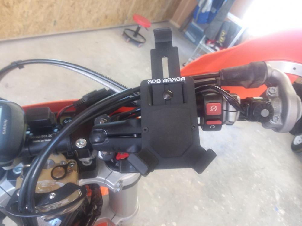
That's nice. Very much like the Mob Armor, but a much better price. I went with the Mob Armor. Found a used one on Amazon. Must have been a returned item. Got it for $37. Just like new.
Here is my setup so far. Got the USB port and the magnetic plug that Luna uses. I've got the Mob Armor on a Ram mount. Probably still needs some tweaking. I've only tested it on the local neighborhood motocross track down the street. So far it's OK
The Dura Force Pro I got has a wonky charge port. I've got a new (used) one on the way. We'll see how that whole USB/power thing works out. I may just run on the phone battery.
LB, are you plugged in or running on the phone battery?

-
Thanks to all for your help.
I have read that Gaia can be unstable on Android. Maybe old news.
Also read that downloading satellite maps into Locus Pro from Google Maps is difficult because the add on app (Locus Map Tweak) doesn't work well or is not easy to use.
Have you heard this or have any additional info?
-
-
On 2/4/2020 at 8:58 AM, luna said:This is right up my alley. I haven't used my Garmin Montana in over a year since converting. There is no comparison, the smartphone is where it's at. Can make routes from your phone in minutes, instead of on a computer, Store offline Satellite maps. I use Kyocera Dura Force Pro Verizon edition. Verizon has 1GB more memory, and the better screen(sapphire). Smartphone and accessories all can be had for around $100.
Here is what I use.Kyrocera Dura Force Pro Verizon Can be had for under a $100. Verizon model is the best.
Silicone Cell Phone holder Tried Ram Mounts, by far silicone mount best, lower to handlebars and stays on.
Magnetic Micro USB Charging Cable In case you're mobbing single tracks, branch pulls on cord, no worries its magnetic, easy to plug back
USB Motorcycle Charge Kit USB plug from battery
Finally to make tracks, my favorite by far is Caltopo
I also use GE, but been using Caltopo as my primary. I do save every gps file I have still in Basecamp.
Finally if you decide on smartphone, you'll have to choose an app. Plenty of good ones out there.Luna, What app do you use for offline satellite maps? Thanks
-
10 hours ago, Mr.JAJA said:No satellite offline.
Thanks for checking.
-
1 hour ago, SpaceCowboy said:Guess I'll give it a go.
It says it comes mapped. I'll keep ya'll updated
Sumthin ain't right.
-
1 hour ago, Mr.JAJA said:"Here" has Satellite view, but I will verify if it works offline tomorrow.
Cool, thanks!


Garmin zūmo® XT anyone using this?
in GPS Stuff
Posted
Garmin 610 for me. Tried the phone as gps. It is ok but not great. 610 is easier to see in sun. Phone is hard to see, and goes dim in heat. Primary is 610. Use phone as secondary aid.