Search the Community
Showing results for tags 'Jacumba'.
Found 1 result
-
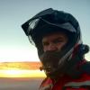
I’ve wanted to check out the Border Run, a dirt road that runs from Campo to Jacumba, for some time. I saddled up the G650GS Sertao for an overnighter with plans to camp somewhere near Corral Canyon. I left San Diego about 2PM on Friday, March 4th and headed to Campo via Olympic Parkway, Otay Lakes Rd, and State Route 94. Map: Ice Cream Sandwich at Otay Lakes Pio Pico Grocery: I was so excited to hit the road that I forgot to gas up before leaving home so my “one gallon left” light came on just before reaching Campo. I gassed up at the Chevron (with a Sinclair Dinosaur in front?) in town and then headed for Corral Canyon OHV. I had plans to complete Corte Madera Road but with the sun setting I decided to just camp in a nice pull-off spot on Los Pinos Road. Springtime in Corral Canyon: Little Half Dome: Corral Canyon and G650GS: Corral Canyon Panoramic: Final Approach to San Diego: Sunset over Corral Canyon: I had my tent, sleeping pad, and sleeping bag all set up before dark. After taking some photos of the sunset I ate a quick dinner and then fell asleep around 6PM. I ended up getting a great night of sleep; thanks to the comfortable Big Agnes sleep system and inflatable pillow I had. Corral Canyon Helmet: Motorcycle Camping: The next morning I packed up and was on the trail by about 6:30AM. I climbed back up Los Pinos and then back down to Four Corners where I decided to tackle the dirt roads of Morrena Stokes Valley and Sky Valley. After finishing these trails I had worked up an appetite and heading into Morena Lake for breakfast at the Oakshore Malt Shop. Thanks to Charley for the recommendation! Sunrise Over Corral Canyon: After breakfast, it was time to top off the tank and head south to the border. The road to the border fence was easy to find thank the map provided by gpsKevin! Border Fence Team Engineer: Motorcycle Mexican Wall: I only came across one Border Patrol Agent who was riding a quad. We exchanged hand waves as we passed each other on the trail. I am glad I spoke with Charley before heading out on the trail. He mentioned a section that required riding on the abandoned train track; something I would have never considered. The hardest part was finding a good place to cross over the metal railing. The actual riding in the center wasn’t nearly as hard as I would have imagined. Please note: This is an abandoned train track. There were other sections that were almost completely grown over but this section, due to the elevated track, seemed to be harder for vegetation to take root and grow. Train track with drops on both sides: Video: After leaving the trail near Tierra Del Sol Road, I took my favorite cruising pace of about 55 MPH via the Old Highway 80. I rode the 80 to Pine Valley but was detoured through the town and ended up discovering Pine Creek Road, which I took all the way to Sunrise Highway. It was a pleasant diversion with some interesting scenery and almost no traffic. I hoped on the fast-paced I-8 for about 8 miles before exiting on Japatul Valley and then continuing south to Lyons Valley. I was really enjoying moving along the twisties at my own pace. East County has some great motorcycle riding that I’ll have to explore more in the future. Valley Overlook from Sunrise Highway: I returned home a bit saddle sore around 2PM. In the last 24 hours I had covered about 240 miles; 60 miles of that was dirt or gravel roads. I didn’t even stop at a Starbucks so I’d say that my weekend counts as an adventure! Until next time… Motorcycle Selfie: Cheers, Travis