

00yz250
-
Content Count
54 -
Joined
-
Last visited
Everything posted by 00yz250
-

Maps and info for local riding areas
00yz250 posted a topic in Important Contact & Info for Riding Areas
I created an index of all of the riding areas in San Diego and Imperial Counties. There’s an information page for each location with a description, permitted activities, trail maps, regulations and links to resources for the area. Let me know if there is any detail that should be added. Use the filter to limit locations to OHV or Motor Vehicles (street legal). http://www.sandiegotrailmap.com/TrailFinder/ -
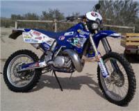
I'm new to the forum and live in PB. I grew up in southern California and I've been exploring the mountains and desert since I was a kid. Past bikes; 1987 CR250, 1986 YZ250, 1985 XL600, 1979 XT500. I now ride a 2000 YZ250 2 stroke that I converted to street legal prior to the laws changing in 2004. I don't think I'll ever buy another bike. It's got a large tank that can go over 90 miles. I like long rides and I'm not a big fan of stopping much along the way. I've got 10 acres of land in Ocotillo Wells and spend a lot of time in the desert during the season. When it gets hot, my bike comes back to San Diego and I ride the smaller local spots. Lee
-
There's a map of the Indian Pass Wilderness and Picacho Peak Wilderness areas here: http://www.sandiegotrailmap.com/TrailFinder/Picacho-Peak-Wilderness/ They're divided by Gavilan Wash which isn't part of either wilderness area. Red and green sticker vehicles are allowed on Gavilan Wash but not Indian Pass Rd or Picacho SRA.
-
It sounds like you're using a really old Topo version. You'd be better off installing Garmin Basecamp and using the free California Topo map from GpsFileDepot: http://www.gpsfiledepot.com/maps/view/523/