

00yz250
-
Content Count
54 -
Joined
-
Last visited
Posts posted by 00yz250
-
-
Coverage area is now all of southern and central California.
The upper boundary is San Jose-Sacramento-Kirkwood-Lake Topaz.
-
The Sierra National Forest was recently added. This area is dense with motor vehicle trails. Mammoth is next.
-
How high can you lift your truck before it hits the ceiling?
-
-
Now includes all of the Sequoia National Forest. (Kennedy Meadows, Monache Meadow, Kern Plateau, Hume Lake)
Lots of juicy single tracks.
-
There is a version of the map that has a "transparent" background. It has dirt roads, trails and POIs but it doesn't include paved roads or a background. If you enable it at the same time as your street map, it will display on top of it. This will allow you to use the routing functionality that comes with your street map. The one odd behavior that you may see is dirt roads that aren't attached to paved roads until you zoom in. This is because I've got some dirt roads set to a higher level than the paved roads on the street map.
-
The primary use case for City Navigator is paved roads. It's missing thousands upon thousands of miles of dirt roads and trails. There is really no comparison. They certainly don't include any single tracks. Off-roading or rural driving is considered an edge case so if they do display a dirt road or rural paved road, it isn't displayed until you zoom in really close. My map is designed to bring dirt roads and trails to the forefront. Depending on the dirt road and the area, I might set the zoom level to the same level as freeway on a Garmin map. Death Valley and Mojave National Preserve are two areas that need this because they're so large with a limited number of roads. Street maps display dirt roads at the same level or lower than residential roads.
Screenshots don't really do it justice because it's a multilevel vector map. It turns into information overload when you display all of the detail. The value in a multi-level map is yielded on a small screen. There are lots of high level screen shots in the Trail Finder.
Take a look at the reviews on Facebook. They're all positive and objective.
-
I am the map maker. The most tedious task is setting the zoom levels(7) on all of the elements to keep it from turning into spaghetti while giving you everything you want to see. My observation has been that smaller screens display the map at a higher density while larger screens spread it out. I recently did a survey and several Nuvi users commented that it doesn't display data soon enough while handheld users said the opposite.
A few solutions for this.
In your GPS map settings, there should be an option along the lines of "Map Detail" or "Detail". You can lower the detail level on small screens and increase it on large screens. This should get rid of those small segments.
I've spent the last two months reviewing and updating the existing coverage area. Over the years of working on the map, I established guidelines for zoom levels and other subjective details. They've improved overtime so I'm updating everything to be consistent. I've been focusing mostly on the mountains and will rework the desert before it cools down.
I added a feature to the Windows installer that asks if you'd like to Show or Hide Non-Motorized Trails. This will help in areas like Big Bear that are dense with trails. This is implemented by copying a style file into the map directory. It's automated on Windows but I'm not sure how to implement on a Mac, yet.
There is an update available if you want to download.
-
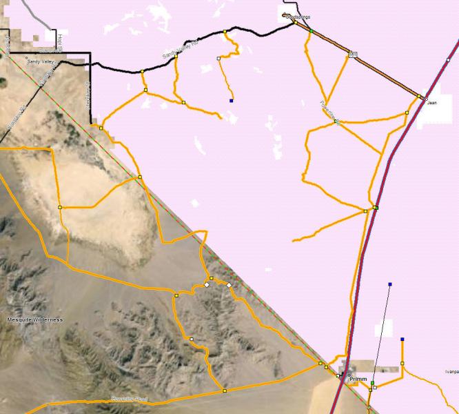
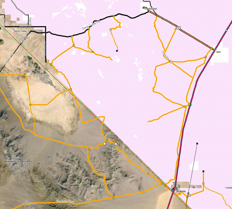
Now includes all of Clark County Nevada in painstaking detail. Esmeralda and Nye counties adjacent to California are included along with the Arizona side of Lake Mead. Over 7,000 miles of dirt roads and trails in Nevada.
-
On 1/24/2016 at 9:23 AM, Vacman said:Bumping up this thread as I bought this last week before my first trip out to Anza Borrego. I bought the 'all platform' version and ran it on my 60csx next to an iPhone running Motion X using USGS maps I downloaded before I left. I used the 60 for primary navigation and Motion X on an old iPhone 5 with the sim card removed in a waterproof/dustproof case for fast zooming/poi and satellite views of where we were.
What a fantastic combination! With the CA Trail Maps I could see every street legal road, turnoff, side canyon, and POI as we rode by. Not only was it awesome to know where we were, but even better was that I knew where every turnoff went and could easily figure out how to get from "here to there." We made an impromptu loop on Saturday and used the map to connect several washes without any chance of getting turned around.
In a perfect world, you would figure out a map server so I could install the map into Motion X instead of buying LeadNav for $20. I know it's not much for an app with so many features, but since I already own and am familiar with Motion X I'd love to have the transparent maps to overlay. Any chance of that in the future, possibly as a sideload? My iphone only has Motion X and Google Drive on it, so it has ~10g of free storage.
Thanks for putting so much hard work into your maps and for updating them so often. And thanks to Goofy Footer for recommending them to me. I only used a tiny sliver of the content you've created and already know I got my money's worth.
Tim
(PS. Any chance of you doing for SDAR what you're doing for Race Dez? Might entice more people to pick it up. :))
The problem with a map server is that it would change the subscription model to a reoccurring cost. You'd need to keep paying me to keep using the map. Most people don't like that idea. They want to own it. On demand file storage in the cloud is cheap relative to running a service 24/7.
LeadNav doesn't seem to display the map at the right scale. The roads and icons are too small. You might try Galileo or one of the other apps. It might be easiest to sample the other apps with one of the smaller coverage areas like central California or Nevada.
I think you're referring to the discount link. It was an idea that never worked so I dropped the price and got rid of it. Nobody ever used the links.
-
The only real use of the version number is to verify that the map loaded on your GPS is the same as the map on your computer. I increment the numbers but I haven't been documenting the contents of each version. In BaseCamp the version is under "Maps\Manage Map Products". On your GPS, the version number is in the same screen that you select the map.
There is another update to the map available that includes more in Clark county. I added Red Rock Canyon, Humboldt-Toiyabe NF, Desert National Wildlife Refuge and tons of BLM land.
-
I did another update. Everything to the east and south of Hwy 160 is solid. Coverage goes to Lake Mead. I still need to do the areas directly east and west of Vegas.
-
I updated the map to include all major trails between California and Vegas. There will be a newer version tomorrow around 10am that will have more labels, pois and a few trails. I haven’t done any city streets in Vegas, yet. Just the highways. Some of the trails look like they end when they get near the city but they connect to residential streets.
-
Any tips / recommendations for putting this map onto an iPhone?
I'd likely use it as a backup to my GPS. The interface on my Garmin 76Cx is quite outdated - I assume there has to be a better gps visual experience 2015.
There's a version of the map that can be loaded into an app on a phone or tablet. It's a raster map so it takes 4gb. The interaction is nice and the visual is a lot sharper than a GPS. Email me from the website if you want to upgrade.
-
There isn't a gas station in Goodsprings. I'm working on the east side of 15 right now. There are a few powerline roads you can take from Primm to Goodsprings.
-
Yesterday! Check your spam folder, if you've got one. You can also use the contact page to have the download link resent.
-
I updated the map to include all of southern California, Inyo county and part of Nevada.
Works on Android, iPhone, Garmin, Lowrance, Mac and PC.
-
The Ojos Negros jump is the most infamous spot on the course. That's the craziest I've ever seen it. Spectator turnout is a lot lower since the economy took a dip. I honestly think the population in Ensenada has dropped. It's a lot easier to get around during the race. The course is running the other direction this year so they won't be hitting the hill from the right side. Zoo road is a popular spot on the San Felipe side but it can get nuts too. Really dusty and vehicles taking multiple tracks.
I use 45mph to make sure I get there on time. It will likely be a little lower. Motorcycles start at 6am, Trucks and cars at 11am.
-
That's the return route. You're not going to see as many vehicles and they'll be large gaps between them. The start of the race is more fun to watch. You see all of the vehicles over a short period of time and they're closer together so you see more passing and nerfing action. About 100 miles into the race is good. The classes start getting mixed up and it gets interesting. The lead vehicle usually averages around 45 mph. I use that to estimate where I need to be on the course at a given time. ex. They'll be around 450 miles into the race after 10 hours.
Here is a video that I took a few years back.
-
I think Bear Valley got a lot of rain this week.
-
My biggest two worries about using my iPhone 6+ as a GPS would be biffing it in a crash and vibration rattling it to death.Was riding this weekend with my Android/Samsung Galaxy S4 phone in a RAM mount and got an error code about my phone "shaking". Now I am having intermittent problems with it finding my SIM card. Time for a new phone, so I might just use the old one for the GPS functions.
I'd pull the sim card out and try cleaning the contacts with an eraser. Just re-seating it might help.
-
This app will convert a gpx file to a transparent Garmin map that can be displayed on top of your base map. It's a work around to the inability to upload tracks.
I'm not sure if you can load maps onto the Kenwood version of the Garmin gps.
-
I was riding in Olievenhain and came along a couple having sex in the back of a hatchback. The car was blocking the road and the sides were steep so no way to go around them. I rode right next to them and I could see her looking up in a panic.
-
I used to ride from the 5/805 split to San Marcos via dirt. There was a Mexican village when you dropped down into Carmel Valley. They even had a taco stand. Hwy 56 was the dirt road short cut from Del Mar to Poway.
Otay Mesa. I remember the day the security guard showed up to keep you from riding where they were going to build the amphitheater. He was just standing there in a huge empty field of dirt. Nothing had even changed yet. That hill was fun to charge.
I get deja vu driving through neighborhoods sometimes. The hills are the same but they're full of houses.

Rider missing in OTAY area
in Missing riders
Posted
There are only a few motorized trails up there. They've all been scoured by everybody and their brother today. Driving around on the same roads again isn't going to yield a different result. He most likely took a hiking trail into the wilderness area so he needs to be found by helicopter or drone. LEOs are performing an active search. Civilians in the area will potentially cover up his tracks, create new tracks that will be a distraction or just be a visual distraction when they're performing their search.